Isernhagen Farster Bauerschaft geodata
Isernhagen Farster Bauerschaft (Lower Saxony) is a populated place; located in Germany in Europe/Berlin (GMT+2) time zone. With population of 22,601 people, there are 660 cities with bigger population in this country. Compared to other cities in Germany, 77.1% of cities are located further ↓South; 52.3% of cities are located further →East and 71.2% of cities have higher elevation than Isernhagen Farster Bauerschaft. Note1
Current local time in Isernhagen Farster Bauerschaft:
01:12 PM, TuesdayDifference from your time zone: hours


Isernhagen Farster Bauerschaft GPS coordinates[2]
52° 28' 15.348" North, 9° 50' 30.444" East
| Map corner | latitude | longitude |
|---|---|---|
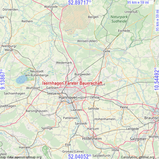
| Upper-left | 52.89717°, | 9.13867° |
| Center: | 52.47093°, | 9.84179° |
| Lower-right: | 52.04052°, | 10.54492° |
| Map W x H: | 95.3×95.2 km | = 59.2×59.2mi |
| max Lat: | 55.01917° ⇑22.9% North |
| Isernhagen Farster Bauerschaft: | 52.47093° |
| min Lat: | ⇓77.1% South 47.40724° |
| min Long | Isernhagen Fars | max Long |
| 5.92978° | 9.84179° | 14.98853° |
| W 47.7%⇐ | ⇒52.3% E |
Elevation
Elevation of Isernhagen Farster Bauerschaft is 83 m = 272 ft, and this is 166.1 m = 545 ft below average elevation for this country.
| Max E: |
1256 m = 4121 ft | 71.2% |
| Avg. | 249.1 m = 817 ft | |
| Isernhagen Farster Bauerschaft | 83 m = 272 ft | |
Min E: |
-5 m = -16 ft | 28.8% |
See also: Germany elevation on elevation.city.
Geographical zone
Isernhagen Farster Bauerschaft is located in North temperate zone (between Tropic of Cancer and the Arctic Circle). Distance of this North polar circle is 1567 km =973.7 mi to North.| Distance of | km | miles | from Isernhagen Farster Bauerschaft |
|---|---|---|---|
| North Pole | 4172.8 | 2592.9 | to North |
| Arctic Circle | 1567 | 973.7 | to North |
| Tropic Cancer | 3228.3 | 2006 | to South |
| Equator | 5834.2 | 3625.2 | to South |


Nearby cities:
15 places around Isernhagen Farster Bauerschaft: (largest is in red/bold)
• Adelheidsdorf
18.1 km =11.2 mi,  55°
55°
• Auf der Horst
17.2 km =10.7 mi,  250°
250°
• Burgdorf
11.5 km =7.1 mi,  103°
103°
• Elze
14.3 km =8.9 mi,  329°
329°
• Garbsen
18.2 km =11.3 mi, 249°
• Garbsen-Mitte
16.9 km =10.5 mi, 253°
• Hannover
13.4 km =8.3 mi,  213°
213°
• Hemmingen
19.2 km =11.9 mi,  204°
204°
• Hänigsen
17 km =10.6 mi,  84°
84°
• Laatzen
17.6 km =10.9 mi,  189°
189°
• Langenhagen
7.5 km =4.7 mi, 249°
• Lehrte
14.4 km =8.9 mi,  139°
139°
• Lindwedel
18.5 km =11.5 mi, 325°
• Negenborn
16.9 km =10.5 mi,  303°
303°
• Seelze
18.5 km =11.5 mi,  243°
243°
Sources, notices
• [Note1] Compared only with cities in Germany existing in our database
• [Src1] Map data: © OpenStreetMap contributors (CC-BY-SA)
• [Src2] Other city data from geonames.org with taken over terms of usage.
• [Src3] Geographical zone / Annual Mean Temperature by Robert A. Rohde @ Wikipedia
