Rhoden geodata
Rhoden (Hesse) is a seat of a fourth-order administrative division; located in Germany in Europe/Berlin (GMT+2) time zone. In our database, there are 11009 cities with bigger population. Compared to other cities in Germany, 65.9% of cities are located further ↓South; 65.3% of cities are located further →East and 61.7% of cities have lower elevation than Rhoden. Note1
Administrative division(s):
- Level 1: Hesse
- Level 2: Regierungsbezirk Kassel
- Level 3: Landkreis Waldeck-Frankenberg
- Level 4: Diemelstadt


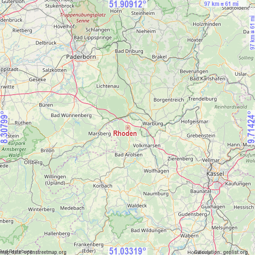
Rhoden GPS coordinates[2]
51° 28' 23.736" North, 9° 0' 39.996" East
| Map corner | latitude | longitude |
|---|---|---|
| Upper-left | 51.90912°, | 8.30799° |
| Center: | 51.47326°, | 9.01111° |
| Lower-right: | 51.03319°, | 9.71424° |
| Map W x H: | 97.4×97.4 km | = 60.5×60.5mi |
| max Lat: | 55.01917° ⇑34.1% North |
| Rhoden: | 51.47326° |
| min Lat: | ⇓65.9% South 47.40724° |
| min Long | Rhoden | max Long |
| 5.92978° | 9.01111° | 14.98853° |
| W 34.7%⇐ | ⇒65.3% E |
Elevation
Elevation of Rhoden is 300 m = 984 ft, and this is 50.9 m = 167 ft above average elevation for this country.
| Max E: |
1256 m = 4121 ft | 38.3% |
| Rhoden | 300 m 984 ft | |
| Avg. | 249.1 m = 817 ft | |
Min E: |
-5 m = -16 ft | 61.7% |
See also: Germany elevation on elevation.city.
Geographical zone
Rhoden is located in North temperate zone (between Tropic of Cancer and the Arctic Circle). Distance of this North polar circle is 1677.9 km =1042.6 mi to North.| Distance of | km | miles | from Rhoden |
|---|---|---|---|
| North Pole | 4283.8 | 2661.8 | to North |
| Arctic Circle | 1677.9 | 1042.6 | to North |
| Tropic Cancer | 3117.4 | 1937.1 | to South |
| Equator | 5723.3 | 3556.3 | to South |


Nearby cities:
15 places around Rhoden: (largest is in red/bold)
• Bad Arolsen
10.4 km =6.5 mi,  178°
178°
• Borgentreich
19.2 km =11.9 mi,  56°
56°
• Breuna
13.6 km =8.5 mi,  117°
117°
• Hofgeismar
26 km =16.2 mi,  84°
84°
• Korbach
24 km =14.9 mi,  203°
203°
• Lichtenau
17.8 km =11.1 mi,  333°
333°
• Liebenau
18.9 km =11.7 mi, 81°
• Marsberg
11.3 km =7 mi,  263°
263°
• Sachsenhausen
25.6 km =15.9 mi, 180°
• Volkmarsen
10.3 km =6.4 mi,  133°
133°
• Warburg
9.6 km =6 mi, 78°
• Willebadessen
17 km =10.6 mi,  6°
6°
• Wolfhagen
19.7 km =12.2 mi,  146°
146°
• Wünnenberg
22.2 km =13.8 mi,  283°
283°
• Zierenberg
23.2 km =14.4 mi, 119°
Sources, notices
• [Note1] Compared only with cities in Germany existing in our database
• [Src1] Map data: © OpenStreetMap contributors (CC-BY-SA)
• [Src2] Other city data from geonames.org with taken over terms of usage.
• [Src3] Geographical zone / Annual Mean Temperature by Robert A. Rohde @ Wikipedia
