Warburg geodata
Warburg (North Rhine-Westphalia) is a populated place; located in Germany in Europe/Berlin (GMT+2) time zone. With population of 24,317 people, there are 613 cities with bigger population in this country. Compared to other cities in Germany, 66.1% of cities are located further ↓South; 63.3% of cities are located further →East and 53.5% of cities have higher elevation than Warburg. Note1
Administrative division(s):
- Level 1: North Rhine-Westphalia
- Level 2: Regierungsbezirk Detmold
- Level 3: Kreis Höxter
- Level 4: Warburg


Warburg GPS coordinates[2]
51° 29' 24.396" North, 9° 8' 47.076" East
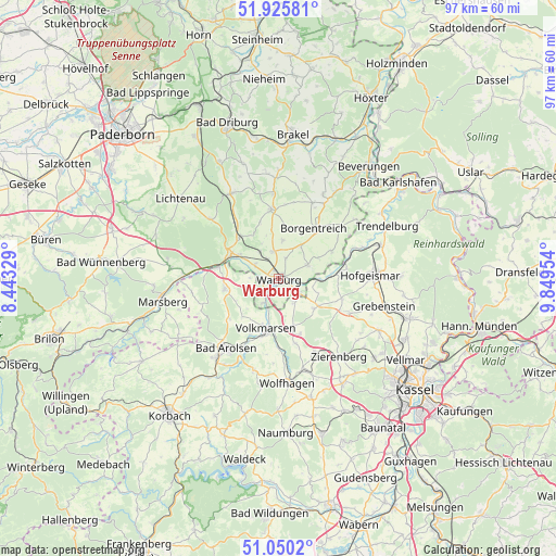
| Map corner | latitude | longitude |
|---|---|---|
| Upper-left | 51.92581°, | 8.44329° |
| Center: | 51.49011°, | 9.14641° |
| Lower-right: | 51.0502°, | 9.84954° |
| Map W x H: | 97.4×97.4 km | = 60.5×60.5mi |
| max Lat: | 55.01917° ⇑33.9% North |
| Warburg: | 51.49011° |
| min Lat: | ⇓66.1% South 47.40724° |
| min Long | Warburg | max Long |
| 5.92978° | 9.14641° | 14.98853° |
| W 36.7%⇐ | ⇒63.3% E |
Elevation
Elevation of Warburg is 200 m = 656 ft, and this is 49.1 m = 161 ft below average elevation for this country.
| Max E: |
1256 m = 4121 ft | 53.5% |
| Avg. | 249.1 m = 817 ft | |
| Warburg | 200 m = 656 ft | |
Min E: |
-5 m = -16 ft | 46.5% |
See also: Germany elevation on elevation.city.
Geographical zone
Warburg is located in North temperate zone (between Tropic of Cancer and the Arctic Circle). Distance of this North polar circle is 1676 km =1041.4 mi to North.| Distance of | km | miles | from Warburg |
|---|---|---|---|
| North Pole | 4281.9 | 2660.6 | to North |
| Arctic Circle | 1676 | 1041.4 | to North |
| Tropic Cancer | 3119.2 | 1938.2 | to South |
| Equator | 5725.2 | 3557.5 | to South |


Nearby cities:
15 places around Warburg: (largest is in red/bold)
• Bad Arolsen
15.3 km =9.5 mi,  216°
216°
• Borgentreich
11 km =6.8 mi,  36°
36°
• Breuna
8.7 km =5.4 mi,  162°
162°
• Calden
19.8 km =12.3 mi,  116°
116°
• Grebenstein
19.1 km =11.9 mi,  104°
104°
• Hofgeismar
16.5 km =10.3 mi,  87°
87°
• Liebenau
9.4 km =5.8 mi, 85°
• Marsberg
20.8 km =12.9 mi,  261°
261°
• Rhoden
9.6 km =6 mi, 258°
• Trendelburg
21.2 km =13.2 mi,  63°
63°
• Udenhausen
22.1 km =13.7 mi, 97°
• Volkmarsen
9.2 km =5.7 mi,  192°
192°
• Willebadessen
16.9 km =10.5 mi,  333°
333°
• Wolfhagen
18.3 km =11.4 mi,  174°
174°
• Zierenberg
17.2 km =10.7 mi,  141°
141°
Sources, notices
• [Note1] Compared only with cities in Germany existing in our database
• [Src1] Map data: © OpenStreetMap contributors (CC-BY-SA)
• [Src2] Other city data from geonames.org with taken over terms of usage.
• [Src3] Geographical zone / Annual Mean Temperature by Robert A. Rohde @ Wikipedia
