Tabarz geodata
Tabarz (Thuringia) is a populated place; located in Germany in Europe/Berlin (GMT+2) time zone. With population of 4,192 people, there are 3180 cities with bigger population in this country. Compared to other cities in Germany, 55.6% of cities are located further ↓South; 59.1% of cities are located further ←West and 75.3% of cities have lower elevation than Tabarz. Note1


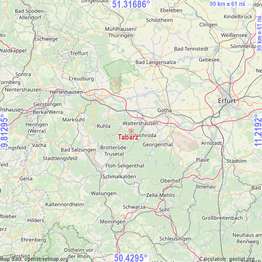
Tabarz GPS coordinates[2]
50° 52' 31.044" North, 10° 30' 57.852" East
| Map corner | latitude | longitude |
|---|---|---|
| Upper-left | 51.31686°, | 9.81295° |
| Center: | 50.87529°, | 10.51607° |
| Lower-right: | 50.4295°, | 11.2192° |
| Map W x H: | 98.7×98.7 km | = 61.3×61.3mi |
| max Lat: | 55.01917° ⇑44.4% North |
| Tabarz: | 50.87529° |
| min Lat: | ⇓55.6% South 47.40724° |
| min Long | Tabarz | max Long |
| 5.92978° | 10.51607° | 14.98853° |
| W 59.1%⇐ | ⇒40.9% E |
Elevation
Elevation of Tabarz is 400 m = 1312 ft, and this is 150.9 m = 495 ft above average elevation for this country.
| Max E: |
1256 m = 4121 ft | 24.7% |
| Tabarz | 400 m 1312 ft | |
| Avg. | 249.1 m = 817 ft | |
Min E: |
-5 m = -16 ft | 75.3% |
See also: Germany elevation on elevation.city.
Geographical zone
Tabarz is located in North temperate zone (between Tropic of Cancer and the Arctic Circle). Distance of this North polar circle is 1744.4 km =1083.9 mi to North.| Distance of | km | miles | from Tabarz |
|---|---|---|---|
| North Pole | 4350.3 | 2703.2 | to North |
| Arctic Circle | 1744.4 | 1083.9 | to North |
| Tropic Cancer | 3050.9 | 1895.7 | to South |
| Equator | 5656.8 | 3515 | to South |


Nearby cities:
15 places around Tabarz: (largest is in red/bold)
• Brotterode
7.6 km =4.7 mi,  221°
221°
• Ernstroda
7.4 km =4.6 mi,  99°
99°
• Finsterbergen
6.8 km =4.2 mi,  131°
131°
• Friedrichroda
4 km =2.5 mi,  119°
119°
• Georgenthal
11.4 km =7.1 mi, 115°
• Hörselgau
6.9 km =4.3 mi,  44°
44°
• Laucha
5.9 km =3.7 mi,  18°
18°
• Mechterstädt
7.4 km =4.6 mi,  4°
4°
• Pappenheim
9.2 km =5.7 mi,  198°
198°
• Ruhla
10.7 km =6.6 mi,  280°
280°
• Seebach
8.4 km =5.2 mi,  303°
303°
• Steinbach
11.7 km =7.3 mi,  246°
246°
• Tambach-Dietharz
11.6 km =7.2 mi,  142°
142°
• Thal
9.8 km =6.1 mi, 297°
• Waltershausen
3.9 km =2.4 mi,  48°
48°
Sources, notices
• [Note1] Compared only with cities in Germany existing in our database
• [Src1] Map data: © OpenStreetMap contributors (CC-BY-SA)
• [Src2] Other city data from geonames.org with taken over terms of usage.
• [Src3] Geographical zone / Annual Mean Temperature by Robert A. Rohde @ Wikipedia
