Spiekeroog geodata
Spiekeroog (Lower Saxony) is a seat of a fourth-order administrative division; located in Germany in Europe/Berlin (GMT+2) time zone. With population of 815 people, there are 7840 cities with bigger population in this country. Compared to other cities in Germany, 89.6% of cities are located further ↓South; 83.1% of cities are located further →East and 96.2% of cities have higher elevation than Spiekeroog. Note1


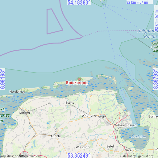
Spiekeroog GPS coordinates[2]
53° 46' 12.432" North, 7° 41' 41.316" East
| Map corner | latitude | longitude |
|---|---|---|
| Upper-left | 54.18363°, | 6.99168° |
| Center: | 53.77012°, | 7.69481° |
| Lower-right: | 53.35249°, | 8.39793° |
| Map W x H: | 92.4×92.4 km | = 57.4×57.4mi |
| max Lat: | 55.01917° ⇑10.4% North |
| Spiekeroog: | 53.77012° |
| min Lat: | ⇓89.6% South 47.40724° |
| min Long | Spiekeroog | max Long |
| 5.92978° | 7.69481° | 14.98853° |
| W 16.9%⇐ | ⇒83.1% E |
Elevation
Elevation of Spiekeroog is 6 m = 20 ft, and this is 243.1 m = 798 ft below average elevation for this country.
| Max E: |
1256 m = 4121 ft | 96.2% |
| Avg. | 249.1 m = 817 ft | |
| Spiekeroog | 6 m = 20 ft | |
Min E: |
-5 m = -16 ft | 3.8% |
See also: Germany elevation on elevation.city.
Geographical zone
Spiekeroog is located in North temperate zone (between Tropic of Cancer and the Arctic Circle). Distance of this North polar circle is 1422.5 km =883.9 mi to North.| Distance of | km | miles | from Spiekeroog |
|---|---|---|---|
| North Pole | 4028.4 | 2503.1 | to North |
| Arctic Circle | 1422.5 | 883.9 | to North |
| Tropic Cancer | 3372.8 | 2095.8 | to South |
| Equator | 5978.7 | 3715 | to South |


Nearby cities:
15 places around Spiekeroog: (largest is in red/bold)
• Baltrum
21.8 km =13.5 mi,  257°
257°
• Bensersiel
13.3 km =8.3 mi,  215°
215°
• Carolinensiel
11.3 km =7 mi,  141°
141°
• Dunum
19.1 km =11.9 mi,  188°
188°
• Esens
14.5 km =9 mi,  201°
201°
• Holtgast
17.5 km =10.9 mi,  206°
206°
• Langeoog
14.1 km =8.8 mi, 260°
• Moorweg
16.9 km =10.5 mi, 205°
• Neuharlingersiel
7.8 km =4.8 mi,  176°
176°
• Ostochtersum
21.3 km =13.2 mi, 211°
• Stedesdorf
15.3 km =9.5 mi, 186°
• Utarp
22 km =13.7 mi, 219°
• Wangerooge
13.6 km =8.5 mi,  80°
80°
• Werdum
12.6 km =7.8 mi,  172°
172°
• Wittmund
22.2 km =13.8 mi, 165°
Sources, notices
• [Note1] Compared only with cities in Germany existing in our database
• [Src1] Map data: © OpenStreetMap contributors (CC-BY-SA)
• [Src2] Other city data from geonames.org with taken over terms of usage.
• [Src3] Geographical zone / Annual Mean Temperature by Robert A. Rohde @ Wikipedia
