Sondershausen geodata
Sondershausen (Thuringia) is a seat of a third-order administrative division; located in Germany in Europe/Berlin (GMT+2) time zone. With population of 21,802 people, there are 692 cities with bigger population in this country. Compared to other cities in Germany, 64.3% of cities are located further ↓South; 65.1% of cities are located further ←West and 54.6% of cities have higher elevation than Sondershausen. Note1


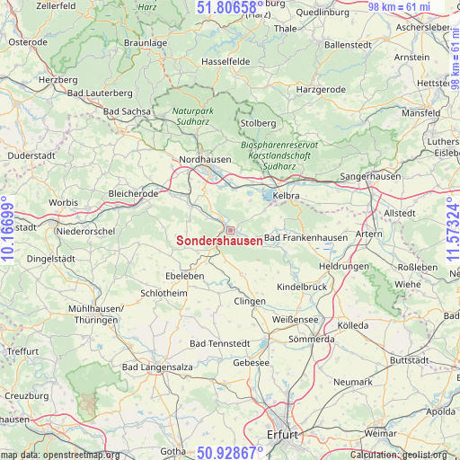
Sondershausen GPS coordinates[2]
51° 22' 11.028" North, 10° 52' 12.396" East
| Map corner | latitude | longitude |
|---|---|---|
| Upper-left | 51.80658°, | 10.16699° |
| Center: | 51.36973°, | 10.87011° |
| Lower-right: | 50.92867°, | 11.57324° |
| Map W x H: | 97.6×97.6 km | = 60.6×60.6mi |
| max Lat: | 55.01917° ⇑35.7% North |
| Sondershausen: | 51.36973° |
| min Lat: | ⇓64.3% South 47.40724° |
| min Long | Sondershausen | max Long |
| 5.92978° | 10.87011° | 14.98853° |
| W 65.1%⇐ | ⇒34.9% E |
Elevation
Elevation of Sondershausen is 192 m = 630 ft, and this is 57.1 m = 187 ft below average elevation for this country.
| Max E: |
1256 m = 4121 ft | 54.6% |
| Avg. | 249.1 m = 817 ft | |
| Sondershausen | 192 m = 630 ft | |
Min E: |
-5 m = -16 ft | 45.4% |
See also: Germany elevation on elevation.city.
Geographical zone
Sondershausen is located in North temperate zone (between Tropic of Cancer and the Arctic Circle). Distance of this North polar circle is 1689.4 km =1049.7 mi to North.| Distance of | km | miles | from Sondershausen |
|---|---|---|---|
| North Pole | 4295.3 | 2669 | to North |
| Arctic Circle | 1689.4 | 1049.7 | to North |
| Tropic Cancer | 3105.9 | 1929.9 | to South |
| Equator | 5711.8 | 3549.1 | to South |


Nearby cities:
15 places around Sondershausen: (largest is in red/bold)
• Auleben
7.5 km =4.7 mi,  33°
33°
• Badra
8.3 km =5.2 mi,  60°
60°
• Bendeleben
9.5 km =5.9 mi,  88°
88°
• Göllingen
10.4 km =6.5 mi,  106°
106°
• Görsbach
11.3 km =7 mi,  24°
24°
• Hachelbich
7.2 km =4.5 mi, 113°
• Heringen
8.6 km =5.3 mi,  2°
2°
• Kleinfurra
8.9 km =5.5 mi,  304°
304°
• Rockstedt
12.1 km =7.5 mi,  218°
218°
• Rottleben
12.3 km =7.6 mi, 93°
• Schernberg
8.4 km =5.2 mi,  236°
236°
• Steinthaleben
11.1 km =6.9 mi,  75°
75°
• Uthleben
9.1 km =5.7 mi,  345°
345°
• Windehausen
10.7 km =6.6 mi, 1°
• Wolkramshausen
10.8 km =6.7 mi, 302°
Sources, notices
• [Note1] Compared only with cities in Germany existing in our database
• [Src1] Map data: © OpenStreetMap contributors (CC-BY-SA)
• [Src2] Other city data from geonames.org with taken over terms of usage.
• [Src3] Geographical zone / Annual Mean Temperature by Robert A. Rohde @ Wikipedia
