Auerbach geodata
Auerbach (Bavaria) is a populated place; located in Germany in Europe/Berlin (GMT+2) time zone. With population of 9,089 people, there are 1773 cities with bigger population in this country. Compared to other cities in Germany, 71.6% of cities are located further ↑North; 76.2% of cities are located further ←West and 81.2% of cities have lower elevation than Auerbach. Note1
Administrative division(s):
- Level 1: Bavaria
- Level 2: Upper Palatinate
- Level 3: Landkreis Amberg-Sulzbach
- Level 4: Auerbach i.d.OPf.


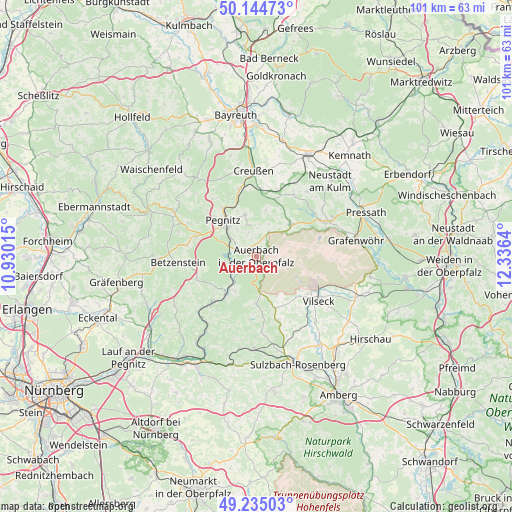
Auerbach GPS coordinates[2]
49° 41' 31.236" North, 11° 37' 59.772" East
| Map corner | latitude | longitude |
|---|---|---|
| Upper-left | 50.14473°, | 10.93015° |
| Center: | 49.69201°, | 11.63327° |
| Lower-right: | 49.23503°, | 12.3364° |
| Map W x H: | 101.1×101.1 km | = 62.8×62.8mi |
| max Lat: | 55.01917° ⇑71.6% North |
| Auerbach: | 49.69201° |
| min Lat: | ⇓28.4% South 47.40724° |
| min Long | Auerbach | max Long |
| 5.92978° | 11.63327° | 14.98853° |
| W 76.2%⇐ | ⇒23.8% E |
Elevation
Elevation of Auerbach is 441 m = 1447 ft, and this is 191.9 m = 630 ft above average elevation for this country.
| Max E: |
1256 m = 4121 ft | 18.8% |
| Auerbach | 441 m 1447 ft | |
| Avg. | 249.1 m = 817 ft | |
Min E: |
-5 m = -16 ft | 81.2% |
See also: Germany elevation on elevation.city.
Geographical zone
Auerbach is located in North temperate zone (between Tropic of Cancer and the Arctic Circle). Distance of this North polar circle is 1875.9 km =1165.6 mi to North.| Distance of | km | miles | from Auerbach |
|---|---|---|---|
| North Pole | 4481.8 | 2784.9 | to North |
| Arctic Circle | 1875.9 | 1165.6 | to North |
| Tropic Cancer | 2919.3 | 1814 | to South |
| Equator | 5525.2 | 3433.2 | to South |


Nearby cities:
15 places around Auerbach: (largest is in red/bold)
• Creußen
17 km =10.6 mi,  358°
358°
• Edelsfeld
13.6 km =8.5 mi,  160°
160°
• Hartenstein
13.2 km =8.2 mi,  219°
219°
• Hirschbach
17.4 km =10.8 mi,  204°
204°
• Kirchenthumbach
9.1 km =5.7 mi,  46°
46°
• Königstein
9.3 km =5.8 mi,  180°
180°
• Neuhaus an der Pegnitz
9.3 km =5.8 mi, 219°
• Pegnitz
9.4 km =5.8 mi,  315°
315°
• Prebitz
16.1 km =10 mi,  12°
12°
• Schlammersdorf
14 km =8.7 mi,  30°
30°
• Schnabelwaid
13.9 km =8.6 mi,  344°
344°
• Speinshart
17.3 km =10.7 mi, 50°
• Velden
12.4 km =7.7 mi,  225°
225°
• Vilseck
14.9 km =9.3 mi,  125°
125°
• Vorbach
16.2 km =10.1 mi, 27°
Sources, notices
• [Note1] Compared only with cities in Germany existing in our database
• [Src1] Map data: © OpenStreetMap contributors (CC-BY-SA)
• [Src2] Other city data from geonames.org with taken over terms of usage.
• [Src3] Geographical zone / Annual Mean Temperature by Robert A. Rohde @ Wikipedia
