Hangard geodata
Hangard (Saarland) is a populated place; located in Germany in Europe/Berlin (GMT+2) time zone. With population of 1,970 people, there are 5106 cities with bigger population in this country. Compared to other cities in Germany, 77.5% of cities are located further ↑North; 91.2% of cities are located further →East and 54.5% of cities have lower elevation than Hangard. Note1
Administrative division(s):
- Level 1: Saarland
- Level 3: Landkreis Neunkirchen
- Level 4: Neunkirchen, Kreisstadt


Hangard GPS coordinates[2]
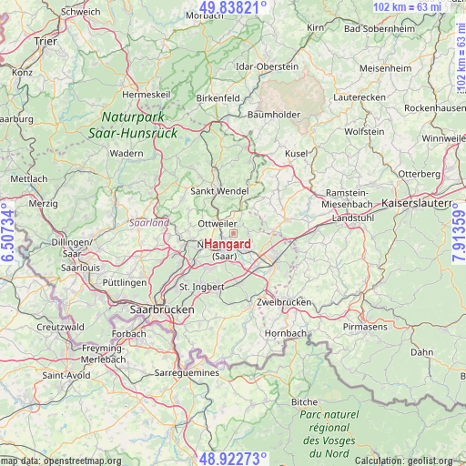
49° 22' 57.36" North, 7° 12' 37.656" East
| Map corner | latitude | longitude |
|---|---|---|
| Upper-left | 49.83821°, | 6.50734° |
| Center: | 49.3826°, | 7.21046° |
| Lower-right: | 48.92273°, | 7.91359° |
| Map W x H: | 101.8×101.8 km | = 63.3×63.3mi |
| max Lat: | 55.01917° ⇑77.5% North |
| Hangard: | 49.3826° |
| min Lat: | ⇓22.5% South 47.40724° |
| min Long | Hangard | max Long |
| 5.92978° | 7.21046° | 14.98853° |
| W 8.8%⇐ | ⇒91.2% E |
Elevation
Elevation of Hangard is 255 m = 837 ft, and this is 5.9 m = 19 ft above average elevation for this country.
| Max E: |
1256 m = 4121 ft | 45.5% |
| Hangard | 255 m 837 ft | |
| Avg. | 249.1 m = 817 ft | |
Min E: |
-5 m = -16 ft | 54.5% |
See also: Germany elevation on elevation.city.
Geographical zone
Hangard is located in North temperate zone (between Tropic of Cancer and the Arctic Circle). Distance of this North polar circle is 1910.3 km =1187 mi to North.| Distance of | km | miles | from Hangard |
|---|---|---|---|
| North Pole | 4516.2 | 2806.2 | to North |
| Arctic Circle | 1910.3 | 1187 | to North |
| Tropic Cancer | 2884.9 | 1792.6 | to South |
| Equator | 5490.8 | 3411.8 | to South |


Nearby cities:
15 places around Hangard: (largest is in red/bold)
• Altenkirchen
10.4 km =6.5 mi,  49°
49°
• Bexbach
5.2 km =3.2 mi,  141°
141°
• Breitenbach
7 km =4.3 mi,  35°
35°
• Dittweiler
10.5 km =6.5 mi,  59°
59°
• Dunzweiler
7.8 km =4.8 mi, 61°
• Friedrichsthal
10.3 km =6.4 mi,  233°
233°
• Frohnhofen
10.2 km =6.3 mi, 39°
• Homburg
11.2 km =7 mi,  123°
123°
• Mainzweiler
7.7 km =4.8 mi,  299°
299°
• Neunkirchen
4.8 km =3 mi,  207°
207°
• Ottweiler
3.9 km =2.4 mi, 301°
• Sankt Wendel
9.8 km =6.1 mi,  341°
341°
• Schiffweiler
5.9 km =3.7 mi,  252°
252°
• Spiesen-Elversberg
9.2 km =5.7 mi,  217°
217°
• Waldmohr
8.9 km =5.5 mi,  89°
89°
Sources, notices
• [Note1] Compared only with cities in Germany existing in our database
• [Src1] Map data: © OpenStreetMap contributors (CC-BY-SA)
• [Src2] Other city data from geonames.org with taken over terms of usage.
• [Src3] Geographical zone / Annual Mean Temperature by Robert A. Rohde @ Wikipedia
