Spiesen-Elversberg geodata
Spiesen-Elversberg (Saarland) is a seat of a fourth-order administrative division; located in Germany in Europe/Berlin (GMT+2) time zone. With population of 14,570 people, there are 1088 cities with bigger population in this country. Compared to other cities in Germany, 78.5% of cities are located further ↑North; 92.1% of cities are located further →East and 69.3% of cities have lower elevation than Spiesen-Elversberg. Note1
Administrative division(s):
- Level 1: Saarland
- Level 3: Landkreis Neunkirchen
- Level 4: Spiesen-Elversberg


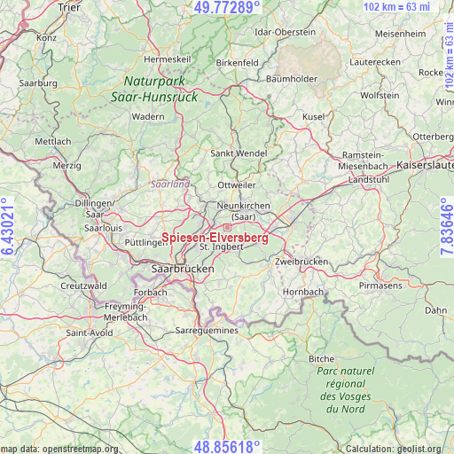
Spiesen-Elversberg GPS coordinates[2]
49° 19' 0.012" North, 7° 7' 59.988" East
| Map corner | latitude | longitude |
|---|---|---|
| Upper-left | 49.77289°, | 6.43021° |
| Center: | 49.31667°, | 7.13333° |
| Lower-right: | 48.85618°, | 7.83646° |
| Map W x H: | 101.9×101.9 km | = 63.3×63.3mi |
| max Lat: | 55.01917° ⇑78.5% North |
| Spiesen-Elversberg: | 49.31667° |
| min Lat: | ⇓21.5% South 47.40724° |
| min Long | Spiesen-Elversb | max Long |
| 5.92978° | 7.13333° | 14.98853° |
| W 7.9%⇐ | ⇒92.1% E |
Elevation
Elevation of Spiesen-Elversberg is 353 m = 1158 ft, and this is 103.9 m = 341 ft above average elevation for this country.
| Max E: |
1256 m = 4121 ft | 30.7% |
| Spiesen-Elversberg | 353 m 1158 ft | |
| Avg. | 249.1 m = 817 ft | |
Min E: |
-5 m = -16 ft | 69.3% |
See also: Germany elevation on elevation.city.
Geographical zone
Spiesen-Elversberg is located in North temperate zone (between Tropic of Cancer and the Arctic Circle). Distance of this North polar circle is 1917.7 km =1191.6 mi to North.| Distance of | km | miles | from Spiesen-Elversberg |
|---|---|---|---|
| North Pole | 4523.6 | 2810.8 | to North |
| Arctic Circle | 1917.7 | 1191.6 | to North |
| Tropic Cancer | 2877.6 | 1788.1 | to South |
| Equator | 5483.5 | 3407.3 | to South |


Nearby cities:
15 places around Spiesen-Elversberg: (largest is in red/bold)
• Bexbach
9.4 km =5.8 mi,  69°
69°
• Blieskastel
12.5 km =7.8 mi,  134°
134°
• Friedrichsthal
3 km =1.9 mi,  294°
294°
• Hangard
9.2 km =5.7 mi,  37°
37°
• Illingen
8.9 km =5.5 mi,  315°
315°
• Kirkel
8.1 km =5 mi,  117°
117°
• Mainzweiler
11.2 km =7 mi,  354°
354°
• Merchweiler
7.1 km =4.4 mi,  301°
301°
• Neunkirchen
4.6 km =2.9 mi,  47°
47°
• Ottweiler
9.7 km =6 mi,  13°
13°
• Quierschied
6 km =3.7 mi,  270°
270°
• Saarbrücken
12.9 km =8 mi,  223°
223°
• Sankt Ingbert
4.6 km =2.9 mi,  195°
195°
• Schiffweiler
5.6 km =3.5 mi,  0°
0°
• Sulzbach
5.9 km =3.7 mi,  250°
250°
Sources, notices
• [Note1] Compared only with cities in Germany existing in our database
• [Src1] Map data: © OpenStreetMap contributors (CC-BY-SA)
• [Src2] Other city data from geonames.org with taken over terms of usage.
• [Src3] Geographical zone / Annual Mean Temperature by Robert A. Rohde @ Wikipedia
