Hohentengen geodata
Hohentengen (Baden-Württemberg) is a seat of a fourth-order administrative division; located in Germany in Europe/Berlin (GMT+2) time zone. With population of 4,453 people, there are 3059 cities with bigger population in this country. Compared to other cities in Germany, 95.1% of cities are located further ↑North; 59.7% of cities are located further →East and 94% of cities have lower elevation than Hohentengen. Note1
Administrative division(s):
- Level 1: Baden-Württemberg
- Level 2: Tübingen Region
- Level 3: Landkreis Sigmaringen
- Level 4: Hohentengen


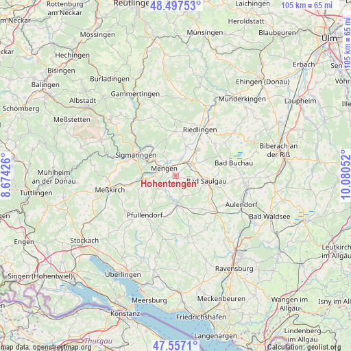
Hohentengen GPS coordinates[2]
48° 1' 46.056" North, 9° 22' 38.604" East
| Map corner | latitude | longitude |
|---|---|---|
| Upper-left | 48.49753°, | 8.67426° |
| Center: | 48.02946°, | 9.37739° |
| Lower-right: | 47.5571°, | 10.08052° |
| Map W x H: | 104.6×104.6 km | = 65×65mi |
| max Lat: | 55.01917° ⇑95.1% North |
| Hohentengen: | 48.02946° |
| min Lat: | ⇓4.9% South 47.40724° |
| min Long | Hohentengen | max Long |
| 5.92978° | 9.37739° | 14.98853° |
| W 40.3%⇐ | ⇒59.7% E |
Elevation
Elevation of Hohentengen is 575 m = 1886 ft, and this is 325.9 m = 1069 ft above average elevation for this country.
| Max E: |
1256 m = 4121 ft | 6% |
| Hohentengen | 575 m 1886 ft | |
| Avg. | 249.1 m = 817 ft | |
Min E: |
-5 m = -16 ft | 94% |
See also: Germany elevation on elevation.city.
Geographical zone
Hohentengen is located in North temperate zone (between Tropic of Cancer and the Arctic Circle). Distance of this North polar circle is 2060.8 km =1280.5 mi to North.| Distance of | km | miles | from Hohentengen |
|---|---|---|---|
| North Pole | 4666.7 | 2899.8 | to North |
| Arctic Circle | 2060.8 | 1280.5 | to North |
| Tropic Cancer | 2734.5 | 1699.1 | to South |
| Equator | 5340.4 | 3318.4 | to South |


Nearby cities:
15 places around Hohentengen: (largest is in red/bold)
• Bingen
12 km =7.5 mi,  319°
319°
• Boms
11.9 km =7.4 mi,  119°
119°
• Ennetach
5 km =3.1 mi,  300°
300°
• Ertingen
10.3 km =6.4 mi,  40°
40°
• Herbertingen
5.9 km =3.7 mi,  45°
45°
• Hoßkirch
10.4 km =6.5 mi,  148°
148°
• Krauchenwies
9.8 km =6.1 mi,  261°
261°
• Königseggwald
11.1 km =6.9 mi,  164°
164°
• Langenenslingen
13.2 km =8.2 mi,  0°
0°
• Mengen
4.2 km =2.6 mi, 302°
• Ostrach
8.8 km =5.5 mi,  177°
177°
• Saulgau
9.3 km =5.8 mi,  98°
98°
• Scheer
7.8 km =4.8 mi,  308°
308°
• Sigmaringen
12.7 km =7.9 mi, 300°
• Sigmaringendorf
9.5 km =5.9 mi, 295°
Sources, notices
• [Note1] Compared only with cities in Germany existing in our database
• [Src1] Map data: © OpenStreetMap contributors (CC-BY-SA)
• [Src2] Other city data from geonames.org with taken over terms of usage.
• [Src3] Geographical zone / Annual Mean Temperature by Robert A. Rohde @ Wikipedia
