Sigmaringen geodata
Sigmaringen (Baden-Württemberg) is a seat of a third-order administrative division; located in Germany in Europe/Berlin (GMT+2) time zone. With population of 16,592 people, there are 952 cities with bigger population in this country. Compared to other cities in Germany, 94.2% of cities are located further ↑North; 61.8% of cities are located further →East and 94.7% of cities have lower elevation than Sigmaringen. Note1
Administrative division(s):
- Level 1: Baden-Württemberg
- Level 2: Tübingen Region
- Level 3: Landkreis Sigmaringen
- Level 4: Sigmaringen


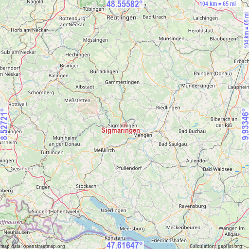
Sigmaringen GPS coordinates[2]
48° 5' 17.844" North, 9° 13' 49.188" East
| Map corner | latitude | longitude |
|---|---|---|
| Upper-left | 48.55582°, | 8.52721° |
| Center: | 48.08829°, | 9.23033° |
| Lower-right: | 47.61647°, | 9.93346° |
| Map W x H: | 104.4×104.4 km | = 64.9×64.9mi |
| max Lat: | 55.01917° ⇑94.2% North |
| Sigmaringen: | 48.08829° |
| min Lat: | ⇓5.8% South 47.40724° |
| min Long | Sigmaringen | max Long |
| 5.92978° | 9.23033° | 14.98853° |
| W 38.2%⇐ | ⇒61.8% E |
Elevation
Elevation of Sigmaringen is 592 m = 1942 ft, and this is 342.9 m = 1125 ft above average elevation for this country.
| Max E: |
1256 m = 4121 ft | 5.3% |
| Sigmaringen | 592 m 1942 ft | |
| Avg. | 249.1 m = 817 ft | |
Min E: |
-5 m = -16 ft | 94.7% |
See also: Germany elevation on elevation.city.
Geographical zone
Sigmaringen is located in North temperate zone (between Tropic of Cancer and the Arctic Circle). Distance of this North polar circle is 2054.3 km =1276.5 mi to North.| Distance of | km | miles | from Sigmaringen |
|---|---|---|---|
| North Pole | 4660.1 | 2895.7 | to North |
| Arctic Circle | 2054.3 | 1276.5 | to North |
| Tropic Cancer | 2741 | 1703.2 | to South |
| Equator | 5346.9 | 3322.4 | to South |


Nearby cities:
15 places around Sigmaringen: (largest is in red/bold)
• Bingen
4 km =2.5 mi,  50°
50°
• Ennetach
7.8 km =4.8 mi,  120°
120°
• Hettingen
14.2 km =8.8 mi,  0°
0°
• Hohentengen
12.7 km =7.9 mi, 120°
• Inzigkofen
4.2 km =2.6 mi,  241°
241°
• Krauchenwies
8.1 km =5 mi,  170°
170°
• Langenenslingen
12.8 km =8 mi,  58°
58°
• Mengen
8.6 km =5.3 mi, 120°
• Meßkirch
13.5 km =8.4 mi,  219°
219°
• Scheer
5.1 km =3.2 mi,  109°
109°
• Sigmaringendorf
3.4 km =2.1 mi,  136°
136°
• Stetten am Kalten Markt
12 km =7.5 mi,  289°
289°
• Straßberg
14.4 km =8.9 mi,  313°
313°
• Veringenstadt
10.9 km =6.8 mi,  352°
352°
• Winterlingen
13.5 km =8.4 mi,  321°
321°
Sources, notices
• [Note1] Compared only with cities in Germany existing in our database
• [Src1] Map data: © OpenStreetMap contributors (CC-BY-SA)
• [Src2] Other city data from geonames.org with taken over terms of usage.
• [Src3] Geographical zone / Annual Mean Temperature by Robert A. Rohde @ Wikipedia
