Kastl geodata
Kastl (Bavaria) is a populated place; located in Germany in Europe/Berlin (GMT+2) time zone. With population of 2,701 people, there are 4231 cities with bigger population in this country. Compared to other cities in Germany, 77.6% of cities are located further ↑North; 76.9% of cities are located further ←West and 83.4% of cities have lower elevation than Kastl. Note1
Administrative division(s):
- Level 1: Bavaria
- Level 2: Upper Palatinate
- Level 3: Landkreis Amberg-Sulzbach
- Level 4: Kastl, Markt


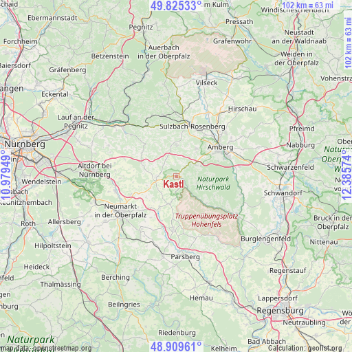
Kastl GPS coordinates[2]
49° 22' 10.56" North, 11° 40' 57.396" East
| Map corner | latitude | longitude |
|---|---|---|
| Upper-left | 49.82533°, | 10.97949° |
| Center: | 49.3696°, | 11.68261° |
| Lower-right: | 48.90961°, | 12.38574° |
| Map W x H: | 101.8×101.8 km | = 63.3×63.3mi |
| max Lat: | 55.01917° ⇑77.6% North |
| Kastl: | 49.3696° |
| min Lat: | ⇓22.4% South 47.40724° |
| min Long | Kastl | max Long |
| 5.92978° | 11.68261° | 14.98853° |
| W 76.9%⇐ | ⇒23.1% E |
Elevation
Elevation of Kastl is 457 m = 1499 ft, and this is 207.9 m = 682 ft above average elevation for this country.
| Max E: |
1256 m = 4121 ft | 16.6% |
| Kastl | 457 m 1499 ft | |
| Avg. | 249.1 m = 817 ft | |
Min E: |
-5 m = -16 ft | 83.4% |
See also: Germany elevation on elevation.city.
Geographical zone
Kastl is located in North temperate zone (between Tropic of Cancer and the Arctic Circle). Distance of this North polar circle is 1911.8 km =1187.9 mi to North.| Distance of | km | miles | from Kastl |
|---|---|---|---|
| North Pole | 4517.7 | 2807.2 | to North |
| Arctic Circle | 1911.8 | 1187.9 | to North |
| Tropic Cancer | 2883.5 | 1791.7 | to South |
| Equator | 5489.4 | 3411 | to South |


Nearby cities:
15 places around Kastl: (largest is in red/bold)
• Alfeld
11.9 km =7.4 mi,  306°
306°
• Amberg
15.4 km =9.6 mi,  57°
57°
• Ammerthal
9.8 km =6.1 mi,  35°
35°
• Berg bei Neumarkt in der Oberpfalz
18.2 km =11.3 mi,  256°
256°
• Hohenburg
11.8 km =7.3 mi,  134°
134°
• Illschwang
8.9 km =5.5 mi,  0°
0°
• Kümmersbruck
15.9 km =9.9 mi,  69°
69°
• Lauterhofen
5.8 km =3.6 mi,  268°
268°
• Pilsach
14.1 km =8.8 mi,  247°
247°
• Poppenricht
14.4 km =8.9 mi, 35°
• Stöckelsberg
17.8 km =11.1 mi,  275°
275°
• Sulzbach-Rosenberg
15.3 km =9.5 mi,  17°
17°
• Ursensollen
6.4 km =4 mi, 55°
• Velburg
15.3 km =9.5 mi,  182°
182°
• Weigendorf
16.5 km =10.3 mi,  329°
329°
Sources, notices
• [Note1] Compared only with cities in Germany existing in our database
• [Src1] Map data: © OpenStreetMap contributors (CC-BY-SA)
• [Src2] Other city data from geonames.org with taken over terms of usage.
• [Src3] Geographical zone / Annual Mean Temperature by Robert A. Rohde @ Wikipedia
