Ursensollen geodata
Ursensollen (Bavaria) is a seat of a fourth-order administrative division; located in Germany in Europe/Berlin (GMT+2) time zone. With population of 3,690 people, there are 3484 cities with bigger population in this country. Compared to other cities in Germany, 77.1% of cities are located further ↑North; 78.1% of cities are located further ←West and 91.7% of cities have lower elevation than Ursensollen. Note1
Administrative division(s):
- Level 1: Bavaria
- Level 2: Upper Palatinate
- Level 3: Landkreis Amberg-Sulzbach
- Level 4: Ursensollen


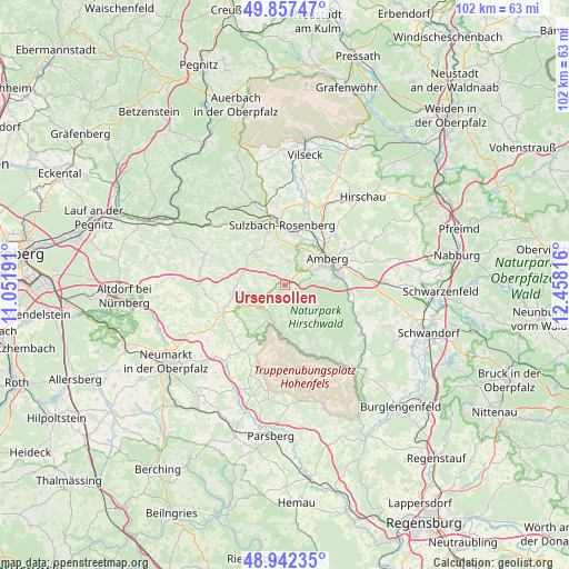
Ursensollen GPS coordinates[2]
49° 24' 7.344" North, 11° 45' 18.108" East
| Map corner | latitude | longitude |
|---|---|---|
| Upper-left | 49.85747°, | 11.05191° |
| Center: | 49.40204°, | 11.75503° |
| Lower-right: | 48.94235°, | 12.45816° |
| Map W x H: | 101.8×101.7 km | = 63.3×63.2mi |
| max Lat: | 55.01917° ⇑77.1% North |
| Ursensollen: | 49.40204° |
| min Lat: | ⇓22.9% South 47.40724° |
| min Long | Ursensollen | max Long |
| 5.92978° | 11.75503° | 14.98853° |
| W 78.1%⇐ | ⇒21.9% E |
Elevation
Elevation of Ursensollen is 538 m = 1765 ft, and this is 288.9 m = 948 ft above average elevation for this country.
| Max E: |
1256 m = 4121 ft | 8.3% |
| Ursensollen | 538 m 1765 ft | |
| Avg. | 249.1 m = 817 ft | |
Min E: |
-5 m = -16 ft | 91.7% |
See also: Germany elevation on elevation.city.
Geographical zone
Ursensollen is located in North temperate zone (between Tropic of Cancer and the Arctic Circle). Distance of this North polar circle is 1908.2 km =1185.7 mi to North.| Distance of | km | miles | from Ursensollen |
|---|---|---|---|
| North Pole | 4514.1 | 2804.9 | to North |
| Arctic Circle | 1908.2 | 1185.7 | to North |
| Tropic Cancer | 2887.1 | 1794 | to South |
| Equator | 5493 | 3413.2 | to South |


Nearby cities:
15 places around Ursensollen: (largest is in red/bold)
• Alfeld
15.2 km =9.4 mi,  283°
283°
• Amberg
9 km =5.6 mi,  59°
59°
• Ammerthal
4.4 km =2.7 mi,  6°
6°
• Ebermannsdorf
13.1 km =8.1 mi,  94°
94°
• Ensdorf
14.8 km =9.2 mi,  117°
117°
• Hahnbach
15.1 km =9.4 mi, 13°
• Hohenburg
12.3 km =7.6 mi,  164°
164°
• Illschwang
7.4 km =4.6 mi,  315°
315°
• Kastl
6.4 km =4 mi,  235°
235°
• Kümmersbruck
9.8 km =6.1 mi,  78°
78°
• Lauterhofen
11.6 km =7.2 mi,  251°
251°
• Poppenricht
8.7 km =5.4 mi,  20°
20°
• Rieden
16.1 km =10 mi, 122°
• Sulzbach-Rosenberg
11.1 km =6.9 mi,  356°
356°
• Weigendorf
17.2 km =10.7 mi,  308°
308°
Sources, notices
• [Note1] Compared only with cities in Germany existing in our database
• [Src1] Map data: © OpenStreetMap contributors (CC-BY-SA)
• [Src2] Other city data from geonames.org with taken over terms of usage.
• [Src3] Geographical zone / Annual Mean Temperature by Robert A. Rohde @ Wikipedia
