Ammerthal geodata
Ammerthal (Bavaria) is a seat of a fourth-order administrative division; located in Germany in Europe/Berlin (GMT+2) time zone. With population of 2,017 people, there are 5045 cities with bigger population in this country. Compared to other cities in Germany, 76.7% of cities are located further ↑North; 78.2% of cities are located further ←West and 81.4% of cities have lower elevation than Ammerthal. Note1
Administrative division(s):
- Level 1: Bavaria
- Level 2: Upper Palatinate
- Level 3: Landkreis Amberg-Sulzbach
- Level 4: Ammerthal


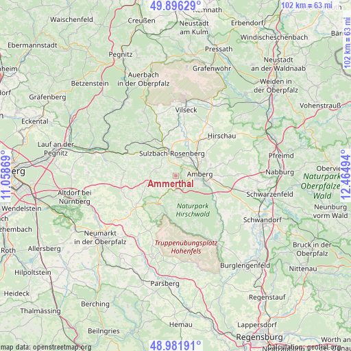
Ammerthal GPS coordinates[2]
49° 26' 28.428" North, 11° 45' 42.516" East
| Map corner | latitude | longitude |
|---|---|---|
| Upper-left | 49.89629°, | 11.05869° |
| Center: | 49.44123°, | 11.76181° |
| Lower-right: | 48.98191°, | 12.46494° |
| Map W x H: | 101.7×101.7 km | = 63.2×63.2mi |
| max Lat: | 55.01917° ⇑76.7% North |
| Ammerthal: | 49.44123° |
| min Lat: | ⇓23.3% South 47.40724° |
| min Long | Ammerthal | max Long |
| 5.92978° | 11.76181° | 14.98853° |
| W 78.2%⇐ | ⇒21.8% E |
Elevation
Elevation of Ammerthal is 443 m = 1453 ft, and this is 193.9 m = 636 ft above average elevation for this country.
| Max E: |
1256 m = 4121 ft | 18.6% |
| Ammerthal | 443 m 1453 ft | |
| Avg. | 249.1 m = 817 ft | |
Min E: |
-5 m = -16 ft | 81.4% |
See also: Germany elevation on elevation.city.
Geographical zone
Ammerthal is located in North temperate zone (between Tropic of Cancer and the Arctic Circle). Distance of this North polar circle is 1903.8 km =1183 mi to North.| Distance of | km | miles | from Ammerthal |
|---|---|---|---|
| North Pole | 4509.7 | 2802.2 | to North |
| Arctic Circle | 1903.8 | 1183 | to North |
| Tropic Cancer | 2891.4 | 1796.6 | to South |
| Equator | 5497.3 | 3415.9 | to South |


Nearby cities:
15 places around Ammerthal: (largest is in red/bold)
• Alfeld
15.3 km =9.5 mi,  266°
266°
• Amberg
7.3 km =4.5 mi,  88°
88°
• Ebermannsdorf
13.6 km =8.5 mi,  112°
112°
• Edelsfeld
15.8 km =9.8 mi,  342°
342°
• Etzelwang
15.9 km =9.9 mi,  307°
307°
• Gebenbach
13.4 km =8.3 mi,  36°
36°
• Hahnbach
10.7 km =6.6 mi,  16°
16°
• Illschwang
5.8 km =3.6 mi,  279°
279°
• Kastl
9.8 km =6.1 mi,  215°
215°
• Kümmersbruck
9.5 km =5.9 mi, 105°
• Lauterhofen
14.1 km =8.8 mi,  234°
234°
• Poppenricht
4.6 km =2.9 mi,  34°
34°
• Sulzbach-Rosenberg
6.8 km =4.2 mi,  350°
350°
• Ursensollen
4.4 km =2.7 mi,  186°
186°
• Weigendorf
15.3 km =9.5 mi,  294°
294°
Sources, notices
• [Note1] Compared only with cities in Germany existing in our database
• [Src1] Map data: © OpenStreetMap contributors (CC-BY-SA)
• [Src2] Other city data from geonames.org with taken over terms of usage.
• [Src3] Geographical zone / Annual Mean Temperature by Robert A. Rohde @ Wikipedia
