Heyen geodata
Heyen (Lower Saxony) is a seat of a fourth-order administrative division; located in Germany in Europe/Berlin (GMT+2) time zone. With population of 552 people, there are 9068 cities with bigger population in this country. Compared to other cities in Germany, 72.2% of cities are located further ↓South; 57.7% of cities are located further →East and 69% of cities have higher elevation than Heyen. Note1


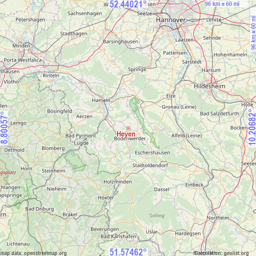
Heyen GPS coordinates[2]
52° 0' 34.236" North, 9° 30' 13.284" East
| Map corner | latitude | longitude |
|---|---|---|
| Upper-left | 52.44021°, | 8.80057° |
| Center: | 52.00951°, | 9.50369° |
| Lower-right: | 51.57462°, | 10.20682° |
| Map W x H: | 96.2×96.2 km | = 59.8×59.8mi |
| max Lat: | 55.01917° ⇑27.8% North |
| Heyen: | 52.00951° |
| min Lat: | ⇓72.2% South 47.40724° |
| min Long | Heyen | max Long |
| 5.92978° | 9.50369° | 14.98853° |
| W 42.3%⇐ | ⇒57.7% E |
Elevation
Elevation of Heyen is 97 m = 318 ft, and this is 152.1 m = 499 ft below average elevation for this country.
| Max E: |
1256 m = 4121 ft | 69% |
| Avg. | 249.1 m = 817 ft | |
| Heyen | 97 m = 318 ft | |
Min E: |
-5 m = -16 ft | 31% |
See also: Germany elevation on elevation.city.
Geographical zone
Heyen is located in North temperate zone (between Tropic of Cancer and the Arctic Circle). Distance of this North polar circle is 1618.3 km =1005.6 mi to North.| Distance of | km | miles | from Heyen |
|---|---|---|---|
| North Pole | 4224.1 | 2624.7 | to North |
| Arctic Circle | 1618.3 | 1005.6 | to North |
| Tropic Cancer | 3177 | 1974.1 | to South |
| Equator | 5782.9 | 3593.3 | to South |


Nearby cities:
15 places around Heyen: (largest is in red/bold)
• Bodenwerder
4.4 km =2.7 mi,  165°
165°
• Brevörde
11.9 km =7.4 mi,  210°
210°
• Coppenbrügge
12.5 km =7.8 mi,  14°
14°
• Dielmissen
8.3 km =5.2 mi,  121°
121°
• Golmbach
12.6 km =7.8 mi, 165°
• Halle
4.7 km =2.9 mi, 115°
• Hehlen
3.3 km =2.1 mi,  224°
224°
• Heinsen
12.4 km =7.7 mi,  61°
61°
• Holenberg
11.7 km =7.3 mi,  152°
152°
• Kirchbrak
6.9 km =4.3 mi,  134°
134°
• Lüerdissen
10.4 km =6.5 mi, 127°
• Ottenstein
9.6 km =6 mi, 223°
• Pegestorf
9.1 km =5.7 mi,  182°
182°
• Salzhemmendorf
8.6 km =5.3 mi,  41°
41°
• Weenzen
11.5 km =7.1 mi,  76°
76°
Sources, notices
• [Note1] Compared only with cities in Germany existing in our database
• [Src1] Map data: © OpenStreetMap contributors (CC-BY-SA)
• [Src2] Other city data from geonames.org with taken over terms of usage.
• [Src3] Geographical zone / Annual Mean Temperature by Robert A. Rohde @ Wikipedia
