Heringen geodata
Heringen (Hesse) is a populated place; located in Germany in Europe/Berlin (GMT+2) time zone. With population of 7,993 people, there are 1956 cities with bigger population in this country. Compared to other cities in Germany, 55.8% of cities are located further ↓South; 50.2% of cities are located further ←West and 50.5% of cities have lower elevation than Heringen. Note1
Administrative division(s):
- Level 1: Hesse
- Level 2: Regierungsbezirk Kassel
- Level 3: Landkreis Hersfeld-Rotenburg
- Level 4: Heringen (Werra)


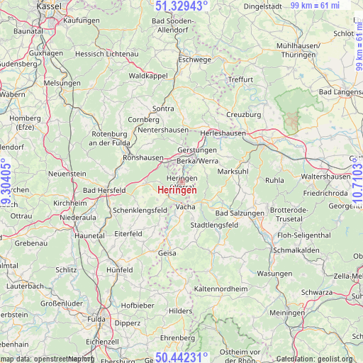
Heringen GPS coordinates[2]
50° 53' 16.728" North, 10° 0' 25.812" East
| Map corner | latitude | longitude |
|---|---|---|
| Upper-left | 51.32943°, | 9.30405° |
| Center: | 50.88798°, | 10.00717° |
| Lower-right: | 50.44231°, | 10.7103° |
| Map W x H: | 98.6×98.6 km | = 61.3×61.3mi |
| max Lat: | 55.01917° ⇑44.2% North |
| Heringen: | 50.88798° |
| min Lat: | ⇓55.8% South 47.40724° |
| min Long | Heringen | max Long |
| 5.92978° | 10.00717° | 14.98853° |
| W 50.2%⇐ | ⇒49.8% E |
Elevation
Elevation of Heringen is 229 m = 751 ft, and this is 20.1 m = 66 ft below average elevation for this country.
| Max E: |
1256 m = 4121 ft | 49.5% |
| Avg. | 249.1 m = 817 ft | |
| Heringen | 229 m = 751 ft | |
Min E: |
-5 m = -16 ft | 50.5% |
See also: Germany elevation on elevation.city.
Geographical zone
Heringen is located in North temperate zone (between Tropic of Cancer and the Arctic Circle). Distance of this North polar circle is 1743 km =1083 mi to North.| Distance of | km | miles | from Heringen |
|---|---|---|---|
| North Pole | 4348.8 | 2702.2 | to North |
| Arctic Circle | 1743 | 1083 | to North |
| Tropic Cancer | 3052.3 | 1896.6 | to South |
| Equator | 5658.2 | 3515.8 | to South |


Nearby cities:
15 places around Heringen: (largest is in red/bold)
• Dankmarshausen
4.2 km =2.6 mi,  8°
8°
• Dippach
4.3 km =2.7 mi,  35°
35°
• Dorndorf
8.3 km =5.2 mi,  135°
135°
• Frauensee
9.5 km =5.9 mi,  96°
96°
• Friedewald
9.9 km =6.2 mi,  266°
266°
• Gerstungen
9.7 km =6 mi,  25°
25°
• Großensee
5.8 km =3.6 mi,  330°
330°
• Martinroda
10.6 km =6.6 mi,  156°
156°
• Philippsthal
5.4 km =3.4 mi,  178°
178°
• Ronshausen
13 km =8.1 mi,  302°
302°
• Schenklengsfeld
13.6 km =8.5 mi,  234°
234°
• Tiefenort
12.4 km =7.7 mi,  115°
115°
• Unterbreizbach
8.1 km =5 mi,  191°
191°
• Vacha
6.8 km =4.2 mi,  171°
171°
• Völkershausen
10.2 km =6.3 mi, 162°
Sources, notices
• [Note1] Compared only with cities in Germany existing in our database
• [Src1] Map data: © OpenStreetMap contributors (CC-BY-SA)
• [Src2] Other city data from geonames.org with taken over terms of usage.
• [Src3] Geographical zone / Annual Mean Temperature by Robert A. Rohde @ Wikipedia
