Gerstungen geodata
Gerstungen (Thuringia) is a seat of a fourth-order administrative division; located in Germany in Europe/Berlin (GMT+2) time zone. With population of 3,865 people, there are 3371 cities with bigger population in this country. Compared to other cities in Germany, 57.5% of cities are located further ↓South; 51.1% of cities are located further ←West and 51% of cities have higher elevation than Gerstungen. Note1


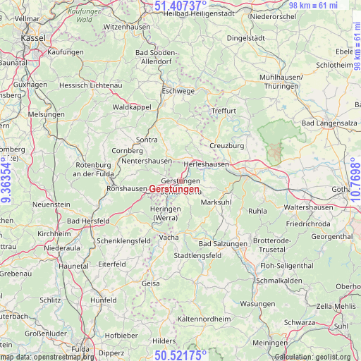
Gerstungen GPS coordinates[2]
50° 58' 0.012" North, 10° 4' 0.012" East
| Map corner | latitude | longitude |
|---|---|---|
| Upper-left | 51.40737°, | 9.36354° |
| Center: | 50.96667°, | 10.06667° |
| Lower-right: | 50.52175°, | 10.7698° |
| Map W x H: | 98.5×98.5 km | = 61.2×61.2mi |
| max Lat: | 55.01917° ⇑42.5% North |
| Gerstungen: | 50.96667° |
| min Lat: | ⇓57.5% South 47.40724° |
| min Long | Gerstungen | max Long |
| 5.92978° | 10.06667° | 14.98853° |
| W 51.1%⇐ | ⇒48.9% E |
Elevation
Elevation of Gerstungen is 218 m = 715 ft, and this is 31.1 m = 102 ft below average elevation for this country.
| Max E: |
1256 m = 4121 ft | 51% |
| Avg. | 249.1 m = 817 ft | |
| Gerstungen | 218 m = 715 ft | |
Min E: |
-5 m = -16 ft | 49% |
See also: Germany elevation on elevation.city.
Geographical zone
Gerstungen is located in North temperate zone (between Tropic of Cancer and the Arctic Circle). Distance of this North polar circle is 1734.2 km =1077.6 mi to North.| Distance of | km | miles | from Gerstungen |
|---|---|---|---|
| North Pole | 4340.1 | 2696.8 | to North |
| Arctic Circle | 1734.2 | 1077.6 | to North |
| Tropic Cancer | 3061 | 1902 | to South |
| Equator | 5667 | 3521.3 | to South |


Nearby cities:
15 places around Gerstungen: (largest is in red/bold)
• Dankmarshausen
5.8 km =3.6 mi,  217°
217°
• Dippach
5.5 km =3.4 mi,  198°
198°
• Dorndorf
14.8 km =9.2 mi,  173°
173°
• Frauensee
11.2 km =7 mi,  151°
151°
• Großensee
7.9 km =4.9 mi,  242°
242°
• Heringen
9.7 km =6 mi,  205°
205°
• Herleshausen
8.3 km =5.2 mi,  57°
57°
• Ifta
13.8 km =8.6 mi,  36°
36°
• Lauchröden
7 km =4.3 mi, 64°
• Marksuhl
10.9 km =6.8 mi,  120°
120°
• Nentershausen
10.9 km =6.8 mi,  300°
300°
• Oberellen
8.5 km =5.3 mi,  103°
103°
• Philippsthal
14.7 km =9.1 mi, 195°
• Unterellen
6.6 km =4.1 mi,  90°
90°
• Wolfsburg-Unkeroda
14.5 km =9 mi, 104°
Sources, notices
• [Note1] Compared only with cities in Germany existing in our database
• [Src1] Map data: © OpenStreetMap contributors (CC-BY-SA)
• [Src2] Other city data from geonames.org with taken over terms of usage.
• [Src3] Geographical zone / Annual Mean Temperature by Robert A. Rohde @ Wikipedia
