Dippach geodata
Dippach (Thuringia) is a seat of a fourth-order administrative division; located in Germany in Europe/Berlin (GMT+2) time zone. With population of 1,136 people, there are 6746 cities with bigger population in this country. Compared to other cities in Germany, 56.6% of cities are located further ↓South; 50.8% of cities are located further ←West and 51% of cities have higher elevation than Dippach. Note1


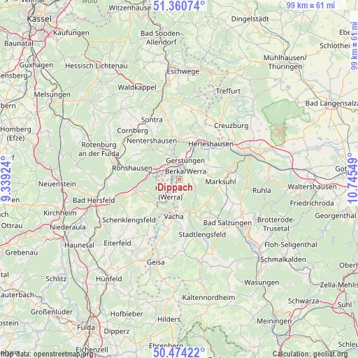
Dippach GPS coordinates[2]
50° 55' 10.524" North, 10° 2' 32.496" East
| Map corner | latitude | longitude |
|---|---|---|
| Upper-left | 51.36074°, | 9.33924° |
| Center: | 50.91959°, | 10.04236° |
| Lower-right: | 50.47422°, | 10.74549° |
| Map W x H: | 98.6×98.6 km | = 61.3×61.3mi |
| max Lat: | 55.01917° ⇑43.4% North |
| Dippach: | 50.91959° |
| min Lat: | ⇓56.6% South 47.40724° |
| min Long | Dippach | max Long |
| 5.92978° | 10.04236° | 14.98853° |
| W 50.8%⇐ | ⇒49.2% E |
Elevation
Elevation of Dippach is 218 m = 715 ft, and this is 31.1 m = 102 ft below average elevation for this country.
| Max E: |
1256 m = 4121 ft | 51% |
| Avg. | 249.1 m = 817 ft | |
| Dippach | 218 m = 715 ft | |
Min E: |
-5 m = -16 ft | 49% |
See also: Germany elevation on elevation.city.
Geographical zone
Dippach is located in North temperate zone (between Tropic of Cancer and the Arctic Circle). Distance of this North polar circle is 1739.4 km =1080.8 mi to North.| Distance of | km | miles | from Dippach |
|---|---|---|---|
| North Pole | 4345.3 | 2700 | to North |
| Arctic Circle | 1739.4 | 1080.8 | to North |
| Tropic Cancer | 3055.8 | 1898.8 | to South |
| Equator | 5661.7 | 3518 | to South |


Nearby cities:
15 places around Dippach: (largest is in red/bold)
• Dankmarshausen
2 km =1.2 mi,  288°
288°
• Dorndorf
10 km =6.2 mi,  160°
160°
• Frauensee
8.4 km =5.2 mi,  123°
123°
• Gerstungen
5.5 km =3.4 mi,  18°
18°
• Großensee
5.5 km =3.4 mi, 286°
• Heringen
4.3 km =2.7 mi,  215°
215°
• Herleshausen
13 km =8.1 mi,  42°
42°
• Lauchröden
11.5 km =7.1 mi, 44°
• Marksuhl
11.1 km =6.9 mi,  91°
91°
• Oberellen
10.5 km =6.5 mi,  72°
72°
• Philippsthal
9.2 km =5.7 mi,  194°
194°
• Tiefenort
12.4 km =7.7 mi,  135°
135°
• Unterbreizbach
12.2 km =7.6 mi,  199°
199°
• Unterellen
9.8 km =6.1 mi,  57°
57°
• Vacha
10.3 km =6.4 mi, 188°
Sources, notices
• [Note1] Compared only with cities in Germany existing in our database
• [Src1] Map data: © OpenStreetMap contributors (CC-BY-SA)
• [Src2] Other city data from geonames.org with taken over terms of usage.
• [Src3] Geographical zone / Annual Mean Temperature by Robert A. Rohde @ Wikipedia
