Rust geodata
Rust (Baden-Württemberg) is a seat of a fourth-order administrative division; located in Germany in Europe/Berlin (GMT+2) time zone. With population of 3,577 people, there are 3556 cities with bigger population in this country. Compared to other cities in Germany, 91.7% of cities are located further ↑North; 82.5% of cities are located further →East and 58.8% of cities have higher elevation than Rust. Note1
Administrative division(s):
- Level 1: Baden-Württemberg
- Level 2: Freiburg Region
- Level 3: Ortenaukreis
- Level 4: Rust


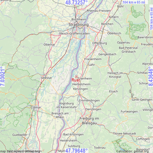
Rust GPS coordinates[2]
48° 16' 0.012" North, 7° 43' 59.988" East
| Map corner | latitude | longitude |
|---|---|---|
| Upper-left | 48.73257°, | 7.03021° |
| Center: | 48.26667°, | 7.73333° |
| Lower-right: | 47.79648°, | 8.43646° |
| Map W x H: | 104.1×104.1 km | = 64.7×64.7mi |
| max Lat: | 55.01917° ⇑91.7% North |
| Rust: | 48.26667° |
| min Lat: | ⇓8.3% South 47.40724° |
| min Long | Rust | max Long |
| 5.92978° | 7.73333° | 14.98853° |
| W 17.5%⇐ | ⇒82.5% E |
Elevation
Elevation of Rust is 162 m = 531 ft, and this is 87.1 m = 286 ft below average elevation for this country.
| Max E: |
1256 m = 4121 ft | 58.8% |
| Avg. | 249.1 m = 817 ft | |
| Rust | 162 m = 531 ft | |
Min E: |
-5 m = -16 ft | 41.2% |
See also: Germany elevation on elevation.city.
Geographical zone
Rust is located in North temperate zone (between Tropic of Cancer and the Arctic Circle). Distance of this North polar circle is 2034.4 km =1264.1 mi to North.| Distance of | km | miles | from Rust |
|---|---|---|---|
| North Pole | 4640.3 | 2883.3 | to North |
| Arctic Circle | 2034.4 | 1264.1 | to North |
| Tropic Cancer | 2760.8 | 1715.5 | to South |
| Equator | 5366.8 | 3334.8 | to South |


Nearby cities:
15 places around Rust: (largest is in red/bold)
• Ettenheim
6 km =3.7 mi,  100°
100°
• Forchheim
11.4 km =7.1 mi,  192°
192°
• Grafenhausen
3.2 km =2 mi,  51°
51°
• Herbolzheim
6.2 km =3.9 mi,  148°
148°
• Kappel-Grafenhausen
3.1 km =1.9 mi, 51°
• Kenzingen
8.3 km =5.2 mi,  160°
160°
• Kippenheim
7.5 km =4.7 mi,  64°
64°
• Lahr
13 km =8.1 mi, 50°
• Mahlberg
6.4 km =4 mi,  69°
69°
• Malterdingen
12.8 km =8 mi, 162°
• Riegel
12.9 km =8 mi,  174°
174°
• Ringsheim
3.9 km =2.4 mi,  122°
122°
• Schwanau
11.3 km =7 mi,  10°
10°
• Weisweil
8.6 km =5.3 mi,  209°
209°
• Wyhl
12.8 km =8 mi, 209°
Sources, notices
• [Note1] Compared only with cities in Germany existing in our database
• [Src1] Map data: © OpenStreetMap contributors (CC-BY-SA)
• [Src2] Other city data from geonames.org with taken over terms of usage.
• [Src3] Geographical zone / Annual Mean Temperature by Robert A. Rohde @ Wikipedia
