Bad Laer geodata
Bad Laer (Lower Saxony) is a seat of a fourth-order administrative division; located in Germany in Europe/Berlin (GMT+2) time zone. With population of 9,151 people, there are 1760 cities with bigger population in this country. Compared to other cities in Germany, 73% of cities are located further ↓South; 75.7% of cities are located further →East and 71.3% of cities have higher elevation than Bad Laer. Note1


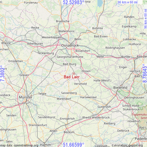
Bad Laer GPS coordinates[2]
52° 6' 0" North, 8° 4' 59.988" East
| Map corner | latitude | longitude |
|---|---|---|
| Upper-left | 52.52983°, | 7.3802° |
| Center: | 52.1°, | 8.08333° |
| Lower-right: | 51.66599°, | 8.78645° |
| Map W x H: | 96.1×96 km | = 59.7×59.7mi |
| max Lat: | 55.01917° ⇑27% North |
| Bad Laer: | 52.1° |
| min Lat: | ⇓73% South 47.40724° |
| min Long | Bad Laer | max Long |
| 5.92978° | 8.08333° | 14.98853° |
| W 24.3%⇐ | ⇒75.7% E |
Elevation
Elevation of Bad Laer is 82 m = 269 ft, and this is 167.1 m = 548 ft below average elevation for this country.
| Max E: |
1256 m = 4121 ft | 71.3% |
| Avg. | 249.1 m = 817 ft | |
| Bad Laer | 82 m = 269 ft | |
Min E: |
-5 m = -16 ft | 28.7% |
See also: Germany elevation on elevation.city.
Geographical zone
Bad Laer is located in North temperate zone (between Tropic of Cancer and the Arctic Circle). Distance of this North polar circle is 1608.2 km =999.3 mi to North.| Distance of | km | miles | from Bad Laer |
|---|---|---|---|
| North Pole | 4214.1 | 2618.5 | to North |
| Arctic Circle | 1608.2 | 999.3 | to North |
| Tropic Cancer | 3187.1 | 1980.4 | to South |
| Equator | 5793 | 3599.6 | to South |


Nearby cities:
15 places around Bad Laer: (largest is in red/bold)
• Bad Iburg
6.7 km =4.2 mi,  335°
335°
• Bad Rothenfelde
6 km =3.7 mi,  71°
71°
• Bissendorf
15.9 km =9.9 mi,  20°
20°
• Borgholzhausen
14.9 km =9.3 mi,  88°
88°
• Dissen
8.1 km =5 mi,  77°
77°
• Georgsmarienhütte
11.7 km =7.3 mi,  347°
347°
• Glandorf
6 km =3.7 mi,  253°
253°
• Hagen
12.8 km =8 mi,  326°
326°
• Hasbergen
17.4 km =10.8 mi, 331°
• Hilter
5.9 km =3.7 mi,  47°
47°
• Lienen
8.8 km =5.5 mi,  309°
309°
• Ostbevern
17.8 km =11.1 mi, 248°
• Sassenberg
12.3 km =7.6 mi,  193°
193°
• Versmold
8.2 km =5.1 mi,  144°
144°
• Warendorf
17.8 km =11.1 mi,  201°
201°
Sources, notices
• [Note1] Compared only with cities in Germany existing in our database
• [Src1] Map data: © OpenStreetMap contributors (CC-BY-SA)
• [Src2] Other city data from geonames.org with taken over terms of usage.
• [Src3] Geographical zone / Annual Mean Temperature by Robert A. Rohde @ Wikipedia
