Ehrenfriedersdorf geodata
Ehrenfriedersdorf (Saxony) is a populated place; located in Germany in Europe/Berlin (GMT+2) time zone. With population of 5,360 people, there are 2678 cities with bigger population in this country. Compared to other cities in Germany, 50.7% of cities are located further ↓South; 92.1% of cities are located further ←West and 91.3% of cities have lower elevation than Ehrenfriedersdorf. Note1


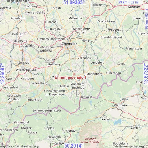
Ehrenfriedersdorf GPS coordinates[2]
50° 38' 57.624" North, 12° 58' 12.324" East
| Map corner | latitude | longitude |
|---|---|---|
| Upper-left | 51.09305°, | 12.26697° |
| Center: | 50.64934°, | 12.97009° |
| Lower-right: | 50.2014°, | 13.67322° |
| Map W x H: | 99.1×99.1 km | = 61.6×61.6mi |
| max Lat: | 55.01917° ⇑49.3% North |
| Ehrenfriedersdorf: | 50.64934° |
| min Lat: | ⇓50.7% South 47.40724° |
| min Long | Ehrenfriedersdo | max Long |
| 5.92978° | 12.97009° | 14.98853° |
| W 92.1%⇐ | ⇒7.9% E |
Elevation
Elevation of Ehrenfriedersdorf is 532 m = 1745 ft, and this is 282.9 m = 928 ft above average elevation for this country.
| Max E: |
1256 m = 4121 ft | 8.7% |
| Ehrenfriedersdorf | 532 m 1745 ft | |
| Avg. | 249.1 m = 817 ft | |
Min E: |
-5 m = -16 ft | 91.3% |
See also: Germany elevation on elevation.city.
Geographical zone
Ehrenfriedersdorf is located in North temperate zone (between Tropic of Cancer and the Arctic Circle). Distance of this North polar circle is 1769.5 km =1099.5 mi to North.| Distance of | km | miles | from Ehrenfriedersdorf |
|---|---|---|---|
| North Pole | 4375.4 | 2718.7 | to North |
| Arctic Circle | 1769.5 | 1099.5 | to North |
| Tropic Cancer | 3025.8 | 1880.1 | to South |
| Equator | 5631.7 | 3499.4 | to South |


Nearby cities:
15 places around Ehrenfriedersdorf: (largest is in red/bold)
• Annaberg-Buchholz
8.2 km =5.1 mi,  161°
161°
• Auerbach
5.3 km =3.3 mi,  315°
315°
• Dorfchemnitz
9.5 km =5.9 mi,  279°
279°
• Drebach
4.4 km =2.7 mi,  47°
47°
• Gelenau
6.9 km =4.3 mi,  357°
357°
• Geyer
4.3 km =2.7 mi,  233°
233°
• Gornsdorf
8.3 km =5.2 mi,  312°
312°
• Hormersdorf
6.8 km =4.2 mi,  293°
293°
• Scharfenstein
8.6 km =5.3 mi, 45°
• Tannenberg
5.2 km =3.2 mi,  205°
205°
• Thermalbad Wiesenbad
6.7 km =4.2 mi,  122°
122°
• Thum
2.7 km =1.7 mi,  330°
330°
• Venusberg
6.5 km =4 mi,  31°
31°
• Wiesa
5.2 km =3.2 mi,  144°
144°
• Wolkenstein
7.2 km =4.5 mi,  84°
84°
Sources, notices
• [Note1] Compared only with cities in Germany existing in our database
• [Src1] Map data: © OpenStreetMap contributors (CC-BY-SA)
• [Src2] Other city data from geonames.org with taken over terms of usage.
• [Src3] Geographical zone / Annual Mean Temperature by Robert A. Rohde @ Wikipedia
