Rudolstadt geodata
Rudolstadt (Thuringia) is a populated place; located in Germany in Europe/Berlin (GMT+2) time zone. With population of 25,476 people, there are 573 cities with bigger population in this country. Compared to other cities in Germany, 52.7% of cities are located further ↓South; 71.8% of cities are located further ←West and 54% of cities have higher elevation than Rudolstadt. Note1


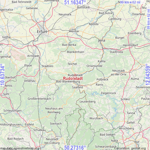
Rudolstadt GPS coordinates[2]
50° 43' 13.548" North, 11° 20' 25.656" East
| Map corner | latitude | longitude |
|---|---|---|
| Upper-left | 51.16347°, | 10.63734° |
| Center: | 50.72043°, | 11.34046° |
| Lower-right: | 50.27316°, | 12.04359° |
| Map W x H: | 99×99 km | = 61.5×61.5mi |
| max Lat: | 55.01917° ⇑47.3% North |
| Rudolstadt: | 50.72043° |
| min Lat: | ⇓52.7% South 47.40724° |
| min Long | Rudolstadt | max Long |
| 5.92978° | 11.34046° | 14.98853° |
| W 71.8%⇐ | ⇒28.2% E |
Elevation
Elevation of Rudolstadt is 197 m = 646 ft, and this is 52.1 m = 171 ft below average elevation for this country.
| Max E: |
1256 m = 4121 ft | 54% |
| Avg. | 249.1 m = 817 ft | |
| Rudolstadt | 197 m = 646 ft | |
Min E: |
-5 m = -16 ft | 46% |
See also: Germany elevation on elevation.city.
Geographical zone
Rudolstadt is located in North temperate zone (between Tropic of Cancer and the Arctic Circle). Distance of this North polar circle is 1761.6 km =1094.6 mi to North.| Distance of | km | miles | from Rudolstadt |
|---|---|---|---|
| North Pole | 4367.5 | 2713.8 | to North |
| Arctic Circle | 1761.6 | 1094.6 | to North |
| Tropic Cancer | 3033.7 | 1885.1 | to South |
| Equator | 5639.6 | 3504.3 | to South |


Nearby cities:
15 places around Rudolstadt: (largest is in red/bold)
• Bad Blankenburg
6.4 km =4 mi,  227°
227°
• Birkigt
11.6 km =7.2 mi,  119°
119°
• Goßwitz
13.5 km =8.4 mi,  134°
134°
• Großkochberg
6.2 km =3.9 mi,  10°
10°
• Kamsdorf
11.7 km =7.3 mi,  137°
137°
• Kaulsdorf
13.2 km =8.2 mi,  150°
150°
• Könitz
13 km =8.1 mi, 127°
• Naundorf
5.1 km =3.2 mi,  103°
103°
• Reichenbach
7.8 km =4.8 mi, 120°
• Reinstädt
13.6 km =8.5 mi,  43°
43°
• Rittersdorf
13.1 km =8.1 mi,  324°
324°
• Rottenbach
12.8 km =8 mi,  253°
253°
• Rückersdorf
9.7 km =6 mi,  78°
78°
• Saalfeld
8.2 km =5.1 mi,  167°
167°
• Unterwellenborn
10.2 km =6.3 mi, 140°
Sources, notices
• [Note1] Compared only with cities in Germany existing in our database
• [Src1] Map data: © OpenStreetMap contributors (CC-BY-SA)
• [Src2] Other city data from geonames.org with taken over terms of usage.
• [Src3] Geographical zone / Annual Mean Temperature by Robert A. Rohde @ Wikipedia
