Großenlüder geodata
Großenlüder (Hesse) is a seat of a fourth-order administrative division; located in Germany in Europe/Berlin (GMT+2) time zone. With population of 8,768 people, there are 1829 cities with bigger population in this country. Compared to other cities in Germany, 50.7% of cities are located further ↑North; 57.1% of cities are located further →East and 54.9% of cities have lower elevation than Großenlüder. Note1
Administrative division(s):
- Level 1: Hesse
- Level 2: Regierungsbezirk Kassel
- Level 3: Landkreis Fulda
- Level 4: Großenlüder


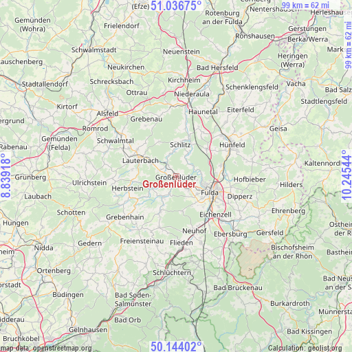
Großenlüder GPS coordinates[2]
50° 35' 33" North, 9° 32' 32.316" East
| Map corner | latitude | longitude |
|---|---|---|
| Upper-left | 51.03675°, | 8.83918° |
| Center: | 50.5925°, | 9.54231° |
| Lower-right: | 50.14402°, | 10.24544° |
| Map W x H: | 99.3×99.3 km | = 61.7×61.7mi |
| max Lat: | 55.01917° ⇑50.7% North |
| Großenlüder: | 50.5925° |
| min Lat: | ⇓49.3% South 47.40724° |
| min Long | Großenlüder | max Long |
| 5.92978° | 9.54231° | 14.98853° |
| W 42.9%⇐ | ⇒57.1% E |
Elevation
Elevation of Großenlüder is 257 m = 843 ft, and this is 7.9 m = 26 ft above average elevation for this country.
| Max E: |
1256 m = 4121 ft | 45.1% |
| Großenlüder | 257 m 843 ft | |
| Avg. | 249.1 m = 817 ft | |
Min E: |
-5 m = -16 ft | 54.9% |
See also: Germany elevation on elevation.city.
Geographical zone
Großenlüder is located in North temperate zone (between Tropic of Cancer and the Arctic Circle). Distance of this North polar circle is 1775.8 km =1103.4 mi to North.| Distance of | km | miles | from Großenlüder |
|---|---|---|---|
| North Pole | 4381.7 | 2722.7 | to North |
| Arctic Circle | 1775.8 | 1103.4 | to North |
| Tropic Cancer | 3019.4 | 1876.2 | to South |
| Equator | 5625.4 | 3495.5 | to South |


Nearby cities:
15 places around Großenlüder: (largest is in red/bold)
• Bad Salzschlirf
4.2 km =2.6 mi,  325°
325°
• Burghaun
17.3 km =10.7 mi,  47°
47°
• Dipperz
18.7 km =11.6 mi,  106°
106°
• Eichenzell
15.4 km =9.6 mi,  134°
134°
• Fulda
10.4 km =6.5 mi,  115°
115°
• Grebenau
17.4 km =10.8 mi,  343°
343°
• Grebenhain
18.4 km =11.4 mi,  231°
231°
• Herbstein
14.3 km =8.9 mi,  255°
255°
• Hosenfeld
10.7 km =6.6 mi,  204°
204°
• Hünfeld
18.6 km =11.6 mi,  58°
58°
• Künzell
13.5 km =8.4 mi, 113°
• Lauterbach
11.3 km =7 mi,  295°
295°
• Lautertal
18.3 km =11.4 mi,  266°
266°
• Neuhof
16.4 km =10.2 mi,  161°
161°
• Schlitz
9.2 km =5.7 mi,  8°
8°
Sources, notices
• [Note1] Compared only with cities in Germany existing in our database
• [Src1] Map data: © OpenStreetMap contributors (CC-BY-SA)
• [Src2] Other city data from geonames.org with taken over terms of usage.
• [Src3] Geographical zone / Annual Mean Temperature by Robert A. Rohde @ Wikipedia
