Fulda geodata
Fulda (Hesse) is a seat of a third-order administrative division; located in Germany in Europe/Berlin (GMT+2) time zone. With population of 63,760 people, there are 163 cities with bigger population in this country. Compared to other cities in Germany, 51.6% of cities are located further ↑North; 54.8% of cities are located further →East and 55.9% of cities have lower elevation than Fulda. Note1
Administrative division(s):
- Level 1: Hesse
- Level 2: Regierungsbezirk Kassel
- Level 3: Landkreis Fulda
- Level 4: Fulda


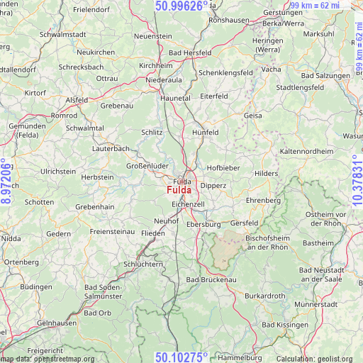
Fulda GPS coordinates[2]
50° 33' 5.832" North, 9° 40' 30.648" East
| Map corner | latitude | longitude |
|---|---|---|
| Upper-left | 50.99626°, | 8.97206° |
| Center: | 50.55162°, | 9.67518° |
| Lower-right: | 50.10275°, | 10.37831° |
| Map W x H: | 99.3×99.3 km | = 61.7×61.7mi |
| max Lat: | 55.01917° ⇑51.6% North |
| Fulda: | 50.55162° |
| min Lat: | ⇓48.4% South 47.40724° |
| min Long | Fulda | max Long |
| 5.92978° | 9.67518° | 14.98853° |
| W 45.2%⇐ | ⇒54.8% E |
Elevation
Elevation of Fulda is 265 m = 869 ft, and this is 15.9 m = 52 ft above average elevation for this country.
| Max E: |
1256 m = 4121 ft | 44.1% |
| Fulda | 265 m 869 ft | |
| Avg. | 249.1 m = 817 ft | |
Min E: |
-5 m = -16 ft | 55.9% |
See also: Fulda elevation on elevation.city.
Geographical zone
Fulda is located in North temperate zone (between Tropic of Cancer and the Arctic Circle). Distance of this North polar circle is 1780.4 km =1106.3 mi to North.| Distance of | km | miles | from Fulda |
|---|---|---|---|
| North Pole | 4386.2 | 2725.5 | to North |
| Arctic Circle | 1780.4 | 1106.3 | to North |
| Tropic Cancer | 3014.9 | 1873.4 | to South |
| Equator | 5620.8 | 3492.6 | to South |


Nearby cities:
15 places around Fulda: (largest is in red/bold)
• Bad Salzschlirf
14.3 km =8.9 mi,  304°
304°
• Burghaun
16.5 km =10.3 mi,  12°
12°
• Dipperz
8.6 km =5.3 mi,  96°
96°
• Eichenzell
6.4 km =4 mi,  166°
166°
• Flieden
16.1 km =10 mi,  208°
208°
• Großenlüder
10.4 km =6.5 mi, 295°
• Hofbieber
11.9 km =7.4 mi,  71°
71°
• Hosenfeld
14.8 km =9.2 mi,  249°
249°
• Hünfeld
15.6 km =9.7 mi,  24°
24°
• Kalbach
16.4 km =10.2 mi,  178°
178°
• Künzell
3.1 km =1.9 mi,  105°
105°
• Motten
18.7 km =11.6 mi,  158°
158°
• Neuhof
11.7 km =7.3 mi,  200°
200°
• Poppenhausen
15.4 km =9.6 mi,  117°
117°
• Schlitz
15.8 km =9.8 mi,  329°
329°
Sources, notices
• [Note1] Compared only with cities in Germany existing in our database
• [Src1] Map data: © OpenStreetMap contributors (CC-BY-SA)
• [Src2] Other city data from geonames.org with taken over terms of usage.
• [Src3] Geographical zone / Annual Mean Temperature by Robert A. Rohde @ Wikipedia
