Hosenfeld geodata
Hosenfeld (Hesse) is a seat of a fourth-order administrative division; located in Germany in Europe/Berlin (GMT+2) time zone. With population of 4,831 people, there are 2887 cities with bigger population in this country. Compared to other cities in Germany, 52.7% of cities are located further ↑North; 58.1% of cities are located further →East and 72.4% of cities have lower elevation than Hosenfeld. Note1
Administrative division(s):
- Level 1: Hesse
- Level 2: Regierungsbezirk Kassel
- Level 3: Landkreis Fulda
- Level 4: Hosenfeld


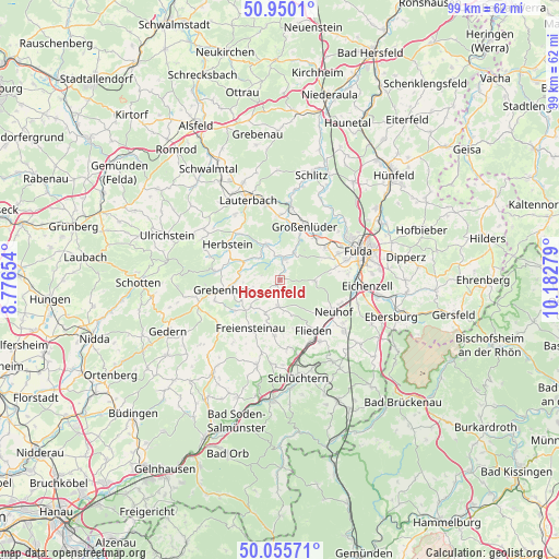
Hosenfeld GPS coordinates[2]
50° 30' 18.072" North, 9° 28' 46.776" East
| Map corner | latitude | longitude |
|---|---|---|
| Upper-left | 50.9501°, | 8.77654° |
| Center: | 50.50502°, | 9.47966° |
| Lower-right: | 50.05571°, | 10.18279° |
| Map W x H: | 99.4×99.4 km | = 61.8×61.8mi |
| max Lat: | 55.01917° ⇑52.7% North |
| Hosenfeld: | 50.50502° |
| min Lat: | ⇓47.3% South 47.40724° |
| min Long | Hosenfeld | max Long |
| 5.92978° | 9.47966° | 14.98853° |
| W 41.9%⇐ | ⇒58.1% E |
Elevation
Elevation of Hosenfeld is 377 m = 1237 ft, and this is 127.9 m = 420 ft above average elevation for this country.
| Max E: |
1256 m = 4121 ft | 27.6% |
| Hosenfeld | 377 m 1237 ft | |
| Avg. | 249.1 m = 817 ft | |
Min E: |
-5 m = -16 ft | 72.4% |
See also: Germany elevation on elevation.city.
Geographical zone
Hosenfeld is located in North temperate zone (between Tropic of Cancer and the Arctic Circle). Distance of this North polar circle is 1785.5 km =1109.5 mi to North.| Distance of | km | miles | from Hosenfeld |
|---|---|---|---|
| North Pole | 4391.4 | 2728.7 | to North |
| Arctic Circle | 1785.5 | 1109.5 | to North |
| Tropic Cancer | 3009.7 | 1870.1 | to South |
| Equator | 5615.6 | 3489.4 | to South |


Nearby cities:
15 places around Hosenfeld: (largest is in red/bold)
• Bad Salzschlirf
13.4 km =8.3 mi,  8°
8°
• Eichenzell
15.4 km =9.6 mi,  94°
94°
• Flieden
10.9 km =6.8 mi,  145°
145°
• Freiensteinau
10.4 km =6.5 mi,  211°
211°
• Fulda
14.8 km =9.2 mi,  69°
69°
• Grebenhain
10.1 km =6.3 mi,  260°
260°
• Großenlüder
10.7 km =6.6 mi,  24°
24°
• Herbstein
11.3 km =7 mi,  303°
303°
• Kalbach
18.2 km =11.3 mi,  127°
127°
• Künzell
17.4 km =10.8 mi,  75°
75°
• Lauterbach
15.6 km =9.7 mi,  338°
338°
• Lautertal
16.4 km =10.2 mi, 302°
• Neuhof
11.3 km =7 mi,  120°
120°
• Schlitz
19.7 km =12.2 mi, 16°
• Schlüchtern
17.7 km =11 mi,  169°
169°
Sources, notices
• [Note1] Compared only with cities in Germany existing in our database
• [Src1] Map data: © OpenStreetMap contributors (CC-BY-SA)
• [Src2] Other city data from geonames.org with taken over terms of usage.
• [Src3] Geographical zone / Annual Mean Temperature by Robert A. Rohde @ Wikipedia
