Grebenhain geodata
Grebenhain (Hesse) is a seat of a fourth-order administrative division; located in Germany in Europe/Berlin (GMT+2) time zone. With population of 5,207 people, there are 2737 cities with bigger population in this country. Compared to other cities in Germany, 53% of cities are located further ↑North; 60.2% of cities are located further →East and 80.3% of cities have lower elevation than Grebenhain. Note1
Administrative division(s):
- Level 1: Hesse
- Level 2: Regierungsbezirk Gießen
- Level 3: Vogelsbergkreis
- Level 4: Grebenhain


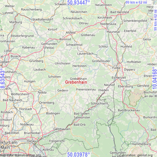
Grebenhain GPS coordinates[2]
50° 29' 21.264" North, 9° 20' 18.78" East
| Map corner | latitude | longitude |
|---|---|---|
| Upper-left | 50.93447°, | 8.63543° |
| Center: | 50.48924°, | 9.33855° |
| Lower-right: | 50.03978°, | 10.04168° |
| Map W x H: | 99.5×99.5 km | = 61.8×61.8mi |
| max Lat: | 55.01917° ⇑53% North |
| Grebenhain: | 50.48924° |
| min Lat: | ⇓47% South 47.40724° |
| min Long | Grebenhain | max Long |
| 5.92978° | 9.33855° | 14.98853° |
| W 39.8%⇐ | ⇒60.2% E |
Elevation
Elevation of Grebenhain is 435 m = 1427 ft, and this is 185.9 m = 610 ft above average elevation for this country.
| Max E: |
1256 m = 4121 ft | 19.7% |
| Grebenhain | 435 m 1427 ft | |
| Avg. | 249.1 m = 817 ft | |
Min E: |
-5 m = -16 ft | 80.3% |
See also: Germany elevation on elevation.city.
Geographical zone
Grebenhain is located in North temperate zone (between Tropic of Cancer and the Arctic Circle). Distance of this North polar circle is 1787.3 km =1110.6 mi to North.| Distance of | km | miles | from Grebenhain |
|---|---|---|---|
| North Pole | 4393.2 | 2729.8 | to North |
| Arctic Circle | 1787.3 | 1110.6 | to North |
| Tropic Cancer | 3008 | 1869.1 | to South |
| Equator | 5613.9 | 3488.3 | to South |


Nearby cities:
15 places around Grebenhain: (largest is in red/bold)
• Bad Salzschlirf
19.2 km =11.9 mi,  38°
38°
• Birstein
15.7 km =9.8 mi,  190°
190°
• Flieden
17.7 km =11 mi,  114°
114°
• Freiensteinau
8.5 km =5.3 mi,  147°
147°
• Gedern
12.2 km =7.6 mi,  234°
234°
• Großenlüder
18.4 km =11.4 mi,  51°
51°
• Herbstein
8 km =5 mi,  3°
3°
• Hirzenhain
17.6 km =10.9 mi,  235°
235°
• Hosenfeld
10.1 km =6.3 mi,  80°
80°
• Kefenrod
18.4 km =11.4 mi,  209°
209°
• Lauterbach
16.8 km =10.4 mi,  14°
14°
• Lautertal
11.2 km =7 mi,  339°
339°
• Neuhof
20.1 km =12.5 mi,  101°
101°
• Schotten
15.2 km =9.4 mi,  275°
275°
• Ulrichstein
14.1 km =8.8 mi,  312°
312°
Sources, notices
• [Note1] Compared only with cities in Germany existing in our database
• [Src1] Map data: © OpenStreetMap contributors (CC-BY-SA)
• [Src2] Other city data from geonames.org with taken over terms of usage.
• [Src3] Geographical zone / Annual Mean Temperature by Robert A. Rohde @ Wikipedia
