Eichenzell geodata
Eichenzell (Hesse) is a seat of a fourth-order administrative division; located in Germany in Europe/Berlin (GMT+2) time zone. With population of 11,042 people, there are 1497 cities with bigger population in this country. Compared to other cities in Germany, 52.9% of cities are located further ↑North; 54.4% of cities are located further →East and 60% of cities have lower elevation than Eichenzell. Note1
Administrative division(s):
- Level 1: Hesse
- Level 2: Regierungsbezirk Kassel
- Level 3: Landkreis Fulda
- Level 4: Eichenzell


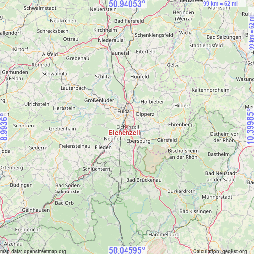
Eichenzell GPS coordinates[2]
50° 29' 43.296" North, 9° 41' 48.192" East
| Map corner | latitude | longitude |
|---|---|---|
| Upper-left | 50.94053°, | 8.9936° |
| Center: | 50.49536°, | 9.69672° |
| Lower-right: | 50.04595°, | 10.39985° |
| Map W x H: | 99.5×99.5 km | = 61.8×61.8mi |
| max Lat: | 55.01917° ⇑52.9% North |
| Eichenzell: | 50.49536° |
| min Lat: | ⇓47.1% South 47.40724° |
| min Long | Eichenzell | max Long |
| 5.92978° | 9.69672° | 14.98853° |
| W 45.6%⇐ | ⇒54.4% E |
Elevation
Elevation of Eichenzell is 290 m = 951 ft, and this is 40.9 m = 134 ft above average elevation for this country.
| Max E: |
1256 m = 4121 ft | 40% |
| Eichenzell | 290 m 951 ft | |
| Avg. | 249.1 m = 817 ft | |
Min E: |
-5 m = -16 ft | 60% |
See also: Germany elevation on elevation.city.
Geographical zone
Eichenzell is located in North temperate zone (between Tropic of Cancer and the Arctic Circle). Distance of this North polar circle is 1786.6 km =1110.1 mi to North.| Distance of | km | miles | from Eichenzell |
|---|---|---|---|
| North Pole | 4392.5 | 2729.4 | to North |
| Arctic Circle | 1786.6 | 1110.1 | to North |
| Tropic Cancer | 3008.6 | 1869.5 | to South |
| Equator | 5614.6 | 3488.7 | to South |


Nearby cities:
15 places around Eichenzell: (largest is in red/bold)
• Bad Salzschlirf
19.5 km =12.1 mi,  317°
317°
• Dipperz
8.8 km =5.5 mi,  52°
52°
• Flieden
12.2 km =7.6 mi,  229°
229°
• Fulda
6.4 km =4 mi,  346°
346°
• Gersfeld
16.1 km =10 mi,  107°
107°
• Großenlüder
15.4 km =9.6 mi,  314°
314°
• Hofbieber
14.1 km =8.8 mi,  44°
44°
• Hosenfeld
15.4 km =9.6 mi,  274°
274°
• Kalbach
10.2 km =6.3 mi,  185°
185°
• Künzell
5.6 km =3.5 mi,  15°
15°
• Motten
12.3 km =7.6 mi,  154°
154°
• Neuhof
7.3 km =4.5 mi, 230°
• Poppenhausen
12.1 km =7.5 mi,  93°
93°
• Schlüchtern
20.3 km =12.6 mi,  216°
216°
• Wildflecken
20 km =12.4 mi,  130°
130°
Sources, notices
• [Note1] Compared only with cities in Germany existing in our database
• [Src1] Map data: © OpenStreetMap contributors (CC-BY-SA)
• [Src2] Other city data from geonames.org with taken over terms of usage.
• [Src3] Geographical zone / Annual Mean Temperature by Robert A. Rohde @ Wikipedia
