Goldisthal geodata
Goldisthal (Thuringia) is a seat of a fourth-order administrative division; located in Germany in Europe/Berlin (GMT+2) time zone. With population of 434 people, there are 9584 cities with bigger population in this country. Compared to other cities in Germany, 52.5% of cities are located further ↑North; 66.9% of cities are located further ←West and 93% of cities have lower elevation than Goldisthal. Note1


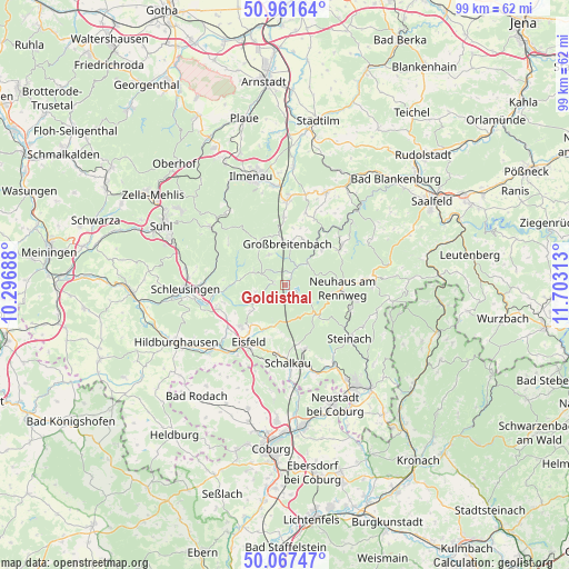
Goldisthal GPS coordinates[2]
50° 31' 0.012" North, 11° 0' 0" East
| Map corner | latitude | longitude |
|---|---|---|
| Upper-left | 50.96164°, | 10.29688° |
| Center: | 50.51667°, | 11° |
| Lower-right: | 50.06747°, | 11.70313° |
| Map W x H: | 99.4×99.4 km | = 61.8×61.8mi |
| max Lat: | 55.01917° ⇑52.5% North |
| Goldisthal: | 50.51667° |
| min Lat: | ⇓47.5% South 47.40724° |
| min Long | Goldisthal | max Long |
| 5.92978° | 11° | 14.98853° |
| W 66.9%⇐ | ⇒33.1% E |
Elevation
Elevation of Goldisthal is 557 m = 1827 ft, and this is 307.9 m = 1010 ft above average elevation for this country.
| Max E: |
1256 m = 4121 ft | 7% |
| Goldisthal | 557 m 1827 ft | |
| Avg. | 249.1 m = 817 ft | |
Min E: |
-5 m = -16 ft | 93% |
See also: Germany elevation on elevation.city.
Geographical zone
Goldisthal is located in North temperate zone (between Tropic of Cancer and the Arctic Circle). Distance of this North polar circle is 1784.2 km =1108.7 mi to North.| Distance of | km | miles | from Goldisthal |
|---|---|---|---|
| North Pole | 4390.1 | 2727.9 | to North |
| Arctic Circle | 1784.2 | 1108.7 | to North |
| Tropic Cancer | 3011 | 1870.9 | to South |
| Equator | 5616.9 | 3490.2 | to South |


Nearby cities:
15 places around Goldisthal: (largest is in red/bold)
• Altenfeld
6 km =3.7 mi,  337°
337°
• Böhlen
8.5 km =5.3 mi,  21°
21°
• Cursdorf
10.9 km =6.8 mi,  59°
59°
• Friedersdorf
10.1 km =6.3 mi,  14°
14°
• Gillersdorf
11.2 km =7 mi, 6°
• Großbreitenbach
7.4 km =4.6 mi, 5°
• Katzhütte
5.4 km =3.4 mi,  43°
43°
• Masserberg
2.1 km =1.3 mi,  279°
279°
• Meuselbach
8.9 km =5.5 mi,  46°
46°
• Neuhaus am Rennweg
9.8 km =6.1 mi,  94°
94°
• Neustadt am Rennsteig
8.8 km =5.5 mi,  327°
327°
• Sachsenbrunn
8.5 km =5.3 mi,  204°
204°
• Scheibe-Alsbach
5.4 km =3.4 mi,  126°
126°
• Steinheid
8.2 km =5.1 mi, 134°
• Wildenspring
10.4 km =6.5 mi,  26°
26°
Sources, notices
• [Note1] Compared only with cities in Germany existing in our database
• [Src1] Map data: © OpenStreetMap contributors (CC-BY-SA)
• [Src2] Other city data from geonames.org with taken over terms of usage.
• [Src3] Geographical zone / Annual Mean Temperature by Robert A. Rohde @ Wikipedia
