Sachsenbrunn geodata
Sachsenbrunn (Thuringia) is a seat of a fourth-order administrative division; located in Germany in Europe/Berlin (GMT+2) time zone. In our database, there are 11009 cities with bigger population. Compared to other cities in Germany, 53.8% of cities are located further ↑North; 66.2% of cities are located further ←West and 86.4% of cities have lower elevation than Sachsenbrunn. Note1


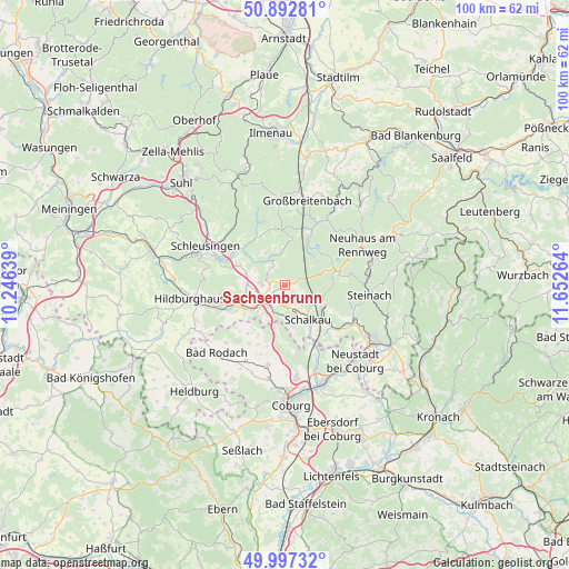
Sachsenbrunn GPS coordinates[2]
50° 26' 49.848" North, 10° 56' 58.236" East
| Map corner | latitude | longitude |
|---|---|---|
| Upper-left | 50.89281°, | 10.24639° |
| Center: | 50.44718°, | 10.94951° |
| Lower-right: | 49.99732°, | 11.65264° |
| Map W x H: | 99.6×99.6 km | = 61.9×61.9mi |
| max Lat: | 55.01917° ⇑53.8% North |
| Sachsenbrunn: | 50.44718° |
| min Lat: | ⇓46.2% South 47.40724° |
| min Long | Sachsenbrunn | max Long |
| 5.92978° | 10.94951° | 14.98853° |
| W 66.2%⇐ | ⇒33.8% E |
Elevation
Elevation of Sachsenbrunn is 481 m = 1578 ft, and this is 231.9 m = 761 ft above average elevation for this country.
| Max E: |
1256 m = 4121 ft | 13.6% |
| Sachsenbrunn | 481 m 1578 ft | |
| Avg. | 249.1 m = 817 ft | |
Min E: |
-5 m = -16 ft | 86.4% |
See also: Germany elevation on elevation.city.
Geographical zone
Sachsenbrunn is located in North temperate zone (between Tropic of Cancer and the Arctic Circle). Distance of this North polar circle is 1792 km =1113.5 mi to North.| Distance of | km | miles | from Sachsenbrunn |
|---|---|---|---|
| North Pole | 4397.9 | 2732.7 | to North |
| Arctic Circle | 1792 | 1113.5 | to North |
| Tropic Cancer | 3003.3 | 1866.2 | to South |
| Equator | 5609.2 | 3485.4 | to South |


Nearby cities:
15 places around Sachsenbrunn: (largest is in red/bold)
• Altenfeld
13.3 km =8.3 mi,  5°
5°
• Bachfeld
4.2 km =2.6 mi,  144°
144°
• Bockstadt
7 km =4.3 mi,  221°
221°
• Eisfeld
3.8 km =2.4 mi,  232°
232°
• Goldisthal
8.5 km =5.3 mi,  24°
24°
• Katzhütte
13.8 km =8.6 mi,  32°
32°
• Lautertal
12.7 km =7.9 mi,  174°
174°
• Masserberg
8.2 km =5.1 mi, 10°
• Meeder
14.3 km =8.9 mi,  192°
192°
• Mengersgereuth-Hämmern
13.1 km =8.1 mi,  115°
115°
• Schalkau
7.1 km =4.4 mi, 144°
• Scheibe-Alsbach
9.2 km =5.7 mi,  60°
60°
• Steinach
14.9 km =9.3 mi,  96°
96°
• Steinheid
9.6 km =6 mi,  77°
77°
• Veilsdorf
10.8 km =6.7 mi,  246°
246°
Sources, notices
• [Note1] Compared only with cities in Germany existing in our database
• [Src1] Map data: © OpenStreetMap contributors (CC-BY-SA)
• [Src2] Other city data from geonames.org with taken over terms of usage.
• [Src3] Geographical zone / Annual Mean Temperature by Robert A. Rohde @ Wikipedia
