Motten geodata
Motten (Bavaria) is a seat of a fourth-order administrative division; located in Germany in Europe/Berlin (GMT+2) time zone. With population of 1,939 people, there are 5153 cities with bigger population in this country. Compared to other cities in Germany, 54.8% of cities are located further ↑North; 53.2% of cities are located further →East and 77.2% of cities have lower elevation than Motten. Note1
Administrative division(s):
- Level 1: Bavaria
- Level 2: Regierungsbezirk Unterfranken
- Level 3: Landkreis Bad Kissingen
- Level 4: Motten


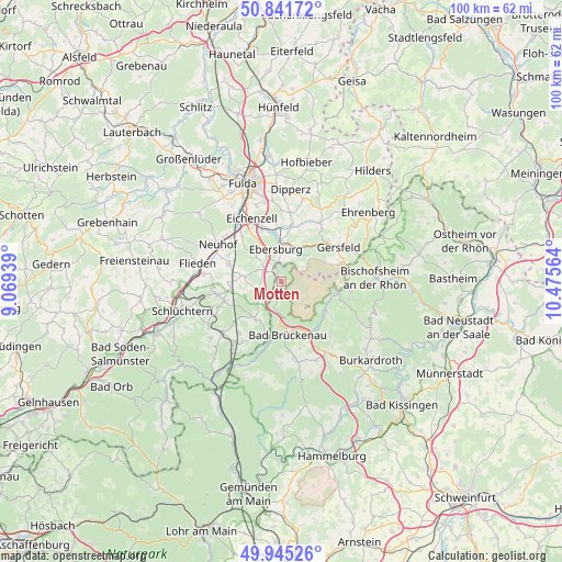
Motten GPS coordinates[2]
50° 23' 44.196" North, 9° 46' 21.036" East
| Map corner | latitude | longitude |
|---|---|---|
| Upper-left | 50.84172°, | 9.06939° |
| Center: | 50.39561°, | 9.77251° |
| Lower-right: | 49.94526°, | 10.47564° |
| Map W x H: | 99.7×99.7 km | = 62×62mi |
| max Lat: | 55.01917° ⇑54.8% North |
| Motten: | 50.39561° |
| min Lat: | ⇓45.2% South 47.40724° |
| min Long | Motten | max Long |
| 5.92978° | 9.77251° | 14.98853° |
| W 46.8%⇐ | ⇒53.2% E |
Elevation
Elevation of Motten is 413 m = 1355 ft, and this is 163.9 m = 538 ft above average elevation for this country.
| Max E: |
1256 m = 4121 ft | 22.8% |
| Motten | 413 m 1355 ft | |
| Avg. | 249.1 m = 817 ft | |
Min E: |
-5 m = -16 ft | 77.2% |
See also: Germany elevation on elevation.city.
Geographical zone
Motten is located in North temperate zone (between Tropic of Cancer and the Arctic Circle). Distance of this North polar circle is 1797.7 km =1117 mi to North.| Distance of | km | miles | from Motten |
|---|---|---|---|
| North Pole | 4403.6 | 2736.3 | to North |
| Arctic Circle | 1797.7 | 1117 | to North |
| Tropic Cancer | 2997.5 | 1862.6 | to South |
| Equator | 5603.5 | 3481.9 | to South |


Nearby cities:
15 places around Motten: (largest is in red/bold)
• Bad Brückenau
9.8 km =6.1 mi,  172°
172°
• Bischofsheim an der Rhön
16.7 km =10.4 mi,  87°
87°
• Dipperz
16.5 km =10.3 mi,  5°
5°
• Eichenzell
12.3 km =7.6 mi,  334°
334°
• Flieden
14.9 km =9.3 mi,  282°
282°
• Geroda
15.5 km =9.6 mi,  145°
145°
• Gersfeld
11.8 km =7.3 mi,  58°
58°
• Kalbach
6.5 km =4 mi, 278°
• Neuhof
12.7 km =7.9 mi,  300°
300°
• Oberleichtersbach
12.6 km =7.8 mi, 171°
• Poppenhausen
12.3 km =7.6 mi,  33°
33°
• Riedenberg
10.5 km =6.5 mi,  143°
143°
• Schondra
15.6 km =9.7 mi,  155°
155°
• Wildflecken
10 km =6.2 mi,  101°
101°
• Zeitlofs
16.5 km =10.3 mi,  205°
205°
Sources, notices
• [Note1] Compared only with cities in Germany existing in our database
• [Src1] Map data: © OpenStreetMap contributors (CC-BY-SA)
• [Src2] Other city data from geonames.org with taken over terms of usage.
• [Src3] Geographical zone / Annual Mean Temperature by Robert A. Rohde @ Wikipedia
