Hofbieber geodata
Hofbieber (Hesse) is a seat of a fourth-order administrative division; located in Germany in Europe/Berlin (GMT+2) time zone. With population of 6,372 people, there are 2343 cities with bigger population in this country. Compared to other cities in Germany, 50.8% of cities are located further ↑North; 52.3% of cities are located further →East and 72.8% of cities have lower elevation than Hofbieber. Note1
Administrative division(s):
- Level 1: Hesse
- Level 2: Regierungsbezirk Kassel
- Level 3: Landkreis Fulda
- Level 4: Hofbieber


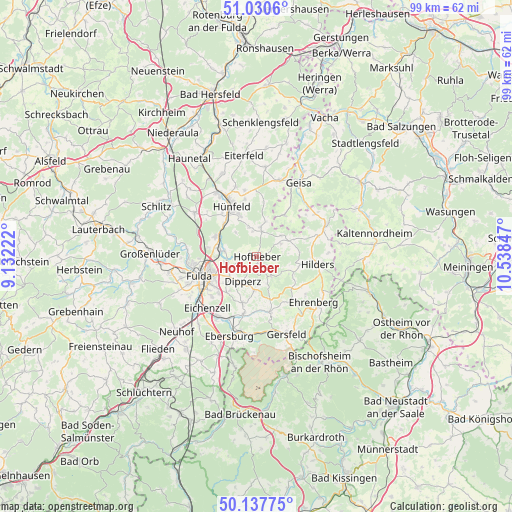
Hofbieber GPS coordinates[2]
50° 35' 10.644" North, 9° 50' 7.224" East
| Map corner | latitude | longitude |
|---|---|---|
| Upper-left | 51.0306°, | 9.13222° |
| Center: | 50.58629°, | 9.83534° |
| Lower-right: | 50.13775°, | 10.53847° |
| Map W x H: | 99.3×99.3 km | = 61.7×61.7mi |
| max Lat: | 55.01917° ⇑50.8% North |
| Hofbieber: | 50.58629° |
| min Lat: | ⇓49.2% South 47.40724° |
| min Long | Hofbieber | max Long |
| 5.92978° | 9.83534° | 14.98853° |
| W 47.7%⇐ | ⇒52.3% E |
Elevation
Elevation of Hofbieber is 380 m = 1247 ft, and this is 130.9 m = 429 ft above average elevation for this country.
| Max E: |
1256 m = 4121 ft | 27.2% |
| Hofbieber | 380 m 1247 ft | |
| Avg. | 249.1 m = 817 ft | |
Min E: |
-5 m = -16 ft | 72.8% |
See also: Germany elevation on elevation.city.
Geographical zone
Hofbieber is located in North temperate zone (between Tropic of Cancer and the Arctic Circle). Distance of this North polar circle is 1776.5 km =1103.9 mi to North.| Distance of | km | miles | from Hofbieber |
|---|---|---|---|
| North Pole | 4382.4 | 2723.1 | to North |
| Arctic Circle | 1776.5 | 1103.9 | to North |
| Tropic Cancer | 3018.7 | 1875.7 | to South |
| Equator | 5624.7 | 3495 | to South |


Nearby cities:
15 places around Hofbieber: (largest is in red/bold)
• Birx
16.3 km =10.1 mi,  111°
111°
• Burghaun
14.6 km =9.1 mi,  327°
327°
• Dipperz
5.5 km =3.4 mi,  210°
210°
• Eichenzell
14.1 km =8.8 mi,  224°
224°
• Fulda
11.9 km =7.4 mi,  251°
251°
• Gersfeld
16 km =9.9 mi,  159°
159°
• Hilders
11.9 km =7.4 mi,  97°
97°
• Hünfeld
11.4 km =7.1 mi,  335°
335°
• Künzell
9.5 km =5.9 mi,  240°
240°
• Oberweid
16.1 km =10 mi,  88°
88°
• Poppenhausen
11.2 km =7 mi,  168°
168°
• Rasdorf
15.2 km =9.4 mi,  17°
17°
• Schleid
15.7 km =9.8 mi,  36°
36°
• Tann
14.7 km =9.1 mi,  64°
64°
• Unterweid
16.1 km =10 mi,  80°
80°
Sources, notices
• [Note1] Compared only with cities in Germany existing in our database
• [Src1] Map data: © OpenStreetMap contributors (CC-BY-SA)
• [Src2] Other city data from geonames.org with taken over terms of usage.
• [Src3] Geographical zone / Annual Mean Temperature by Robert A. Rohde @ Wikipedia
