Rimbach geodata
Rimbach (Bavaria) is a seat of a fourth-order administrative division; located in Germany in Europe/Berlin (GMT+2) time zone. With population of 913 people, there are 7478 cities with bigger population in this country. Compared to other cities in Germany, 89.5% of cities are located further ↑North; 89.3% of cities are located further ←West and 84.1% of cities have lower elevation than Rimbach. Note1
Administrative division(s):
- Level 1: Bavaria
- Level 2: Lower Bavaria
- Level 3: Landkreis Rottal-Inn
- Level 4: Rimbach


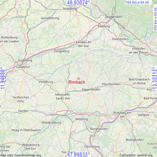
Rimbach GPS coordinates[2]
48° 28' 0.012" North, 12° 39' 0" East
| Map corner | latitude | longitude |
|---|---|---|
| Upper-left | 48.93074°, | 11.94688° |
| Center: | 48.46667°, | 12.65° |
| Lower-right: | 47.99832°, | 13.35313° |
| Map W x H: | 103.7×103.7 km | = 64.4×64.4mi |
| max Lat: | 55.01917° ⇑89.5% North |
| Rimbach: | 48.46667° |
| min Lat: | ⇓10.5% South 47.40724° |
| min Long | Rimbach | max Long |
| 5.92978° | 12.65° | 14.98853° |
| W 89.3%⇐ | ⇒10.7% E |
Elevation
Elevation of Rimbach is 462 m = 1516 ft, and this is 212.9 m = 698 ft above average elevation for this country.
| Max E: |
1256 m = 4121 ft | 15.9% |
| Rimbach | 462 m 1516 ft | |
| Avg. | 249.1 m = 817 ft | |
Min E: |
-5 m = -16 ft | 84.1% |
See also: Germany elevation on elevation.city.
Geographical zone
Rimbach is located in North temperate zone (between Tropic of Cancer and the Arctic Circle). Distance of this North polar circle is 2012.2 km =1250.3 mi to North.| Distance of | km | miles | from Rimbach |
|---|---|---|---|
| North Pole | 4618.1 | 2869.6 | to North |
| Arctic Circle | 2012.2 | 1250.3 | to North |
| Tropic Cancer | 2783.1 | 1729.3 | to South |
| Equator | 5389 | 3348.6 | to South |


Nearby cities:
15 places around Rimbach: (largest is in red/bold)
• Eggenfelden
10.5 km =6.5 mi,  130°
130°
• Falkenberg
6 km =3.7 mi,  95°
95°
• Frontenhausen
12.4 km =7.7 mi,  315°
315°
• Gangkofen
7.1 km =4.4 mi,  242°
242°
• Geratskirchen
14.3 km =8.9 mi,  176°
176°
• Hebertsfelden
14.4 km =8.9 mi,  117°
117°
• Malgersdorf
10.5 km =6.5 mi,  44°
44°
• Marklkofen
11.1 km =6.9 mi,  326°
326°
• Massing
8.9 km =5.5 mi,  199°
199°
• Mitterskirchen
14.4 km =8.9 mi,  154°
154°
• Reisbach
11.6 km =7.2 mi,  351°
351°
• Ruhstorf
8.5 km =5.3 mi,  16°
16°
• Schönau
14.9 km =9.3 mi,  82°
82°
• Simbach
12.8 km =8 mi,  30°
30°
• Unterdietfurt
9.3 km =5.8 mi,  172°
172°
Sources, notices
• [Note1] Compared only with cities in Germany existing in our database
• [Src1] Map data: © OpenStreetMap contributors (CC-BY-SA)
• [Src2] Other city data from geonames.org with taken over terms of usage.
• [Src3] Geographical zone / Annual Mean Temperature by Robert A. Rohde @ Wikipedia
