Mulda geodata
Mulda (Saxony) is a populated place; located in Germany in Europe/Berlin (GMT+2) time zone. With population of 2,936 people, there are 4057 cities with bigger population in this country. Compared to other cities in Germany, 54.3% of cities are located further ↓South; 95.2% of cities are located further ←West and 78.8% of cities have lower elevation than Mulda. Note1


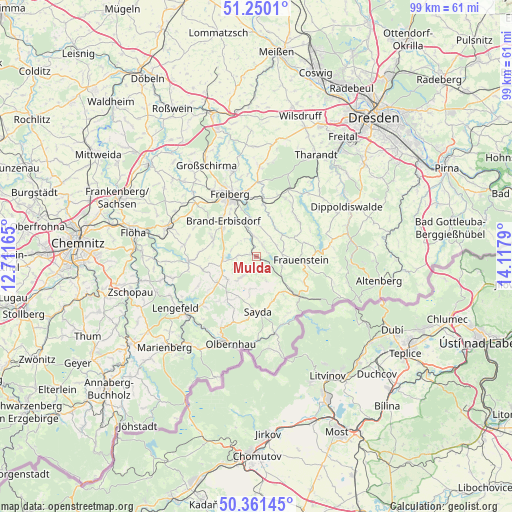
Mulda GPS coordinates[2]
50° 48' 28.404" North, 13° 24' 53.172" East
| Map corner | latitude | longitude |
|---|---|---|
| Upper-left | 51.2501°, | 12.71165° |
| Center: | 50.80789°, | 13.41477° |
| Lower-right: | 50.36145°, | 14.1179° |
| Map W x H: | 98.8×98.8 km | = 61.4×61.4mi |
| max Lat: | 55.01917° ⇑45.7% North |
| Mulda: | 50.80789° |
| min Lat: | ⇓54.3% South 47.40724° |
| min Long | Mulda | max Long |
| 5.92978° | 13.41477° | 14.98853° |
| W 95.2%⇐ | ⇒4.8% E |
Elevation
Elevation of Mulda is 425 m = 1394 ft, and this is 175.9 m = 577 ft above average elevation for this country.
| Max E: |
1256 m = 4121 ft | 21.2% |
| Mulda | 425 m 1394 ft | |
| Avg. | 249.1 m = 817 ft | |
Min E: |
-5 m = -16 ft | 78.8% |
See also: Germany elevation on elevation.city.
Geographical zone
Mulda is located in North temperate zone (between Tropic of Cancer and the Arctic Circle). Distance of this North polar circle is 1751.9 km =1088.6 mi to North.| Distance of | km | miles | from Mulda |
|---|---|---|---|
| North Pole | 4357.8 | 2707.8 | to North |
| Arctic Circle | 1751.9 | 1088.6 | to North |
| Tropic Cancer | 3043.4 | 1891.1 | to South |
| Equator | 5649.3 | 3510.3 | to South |


Nearby cities:
15 places around Mulda: (largest is in red/bold)
• Brand-Erbisdorf
9.2 km =5.7 mi,  315°
315°
• Dorfchemnitz
5.2 km =3.2 mi,  151°
151°
• Eppendorf
12.8 km =8 mi,  266°
266°
• Frauenstein
8.7 km =5.4 mi,  93°
93°
• Freiberg
12.6 km =7.8 mi,  335°
335°
• Gahlenz
14.4 km =8.9 mi,  277°
277°
• Großhartmannsdorf
5.8 km =3.6 mi,  261°
261°
• Heidersdorf
13.9 km =8.6 mi,  184°
184°
• Lichtenberg
3.1 km =1.9 mi,  13°
13°
• Neuhausen
15.1 km =9.4 mi,  165°
165°
• Oberschöna
15.1 km =9.4 mi,  311°
311°
• Pfaffroda
12.8 km =8 mi,  200°
200°
• Pretzschendorf
10.7 km =6.6 mi,  46°
46°
• Rechenberg-Bienenmühle
11.5 km =7.1 mi,  132°
132°
• Sayda
10.8 km =6.7 mi, 177°
Sources, notices
• [Note1] Compared only with cities in Germany existing in our database
• [Src1] Map data: © OpenStreetMap contributors (CC-BY-SA)
• [Src2] Other city data from geonames.org with taken over terms of usage.
• [Src3] Geographical zone / Annual Mean Temperature by Robert A. Rohde @ Wikipedia
