Pfedelbach geodata
Pfedelbach (Baden-Württemberg) is a seat of a fourth-order administrative division; located in Germany in Europe/Berlin (GMT+2) time zone. With population of 8,879 people, there are 1810 cities with bigger population in this country. Compared to other cities in Germany, 80.7% of cities are located further ↑North; 57.7% of cities are located further →East and 51.7% of cities have lower elevation than Pfedelbach. Note1
Administrative division(s):
- Level 1: Baden-Württemberg
- Level 2: Regierungsbezirk Stuttgart
- Level 3: Hohenlohekreis
- Level 4: Pfedelbach


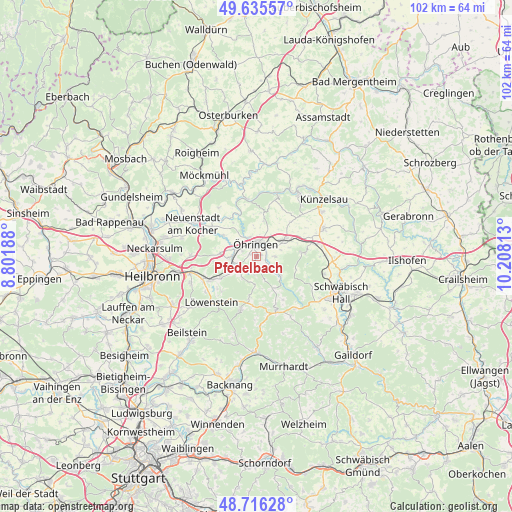
Pfedelbach GPS coordinates[2]
49° 10' 41.016" North, 9° 30' 18" East
| Map corner | latitude | longitude |
|---|---|---|
| Upper-left | 49.63557°, | 8.80188° |
| Center: | 49.17806°, | 9.505° |
| Lower-right: | 48.71628°, | 10.20813° |
| Map W x H: | 102.2×102.2 km | = 63.5×63.5mi |
| max Lat: | 55.01917° ⇑80.7% North |
| Pfedelbach: | 49.17806° |
| min Lat: | ⇓19.3% South 47.40724° |
| min Long | Pfedelbach | max Long |
| 5.92978° | 9.505° | 14.98853° |
| W 42.3%⇐ | ⇒57.7% E |
Elevation
Elevation of Pfedelbach is 238 m = 781 ft, and this is 11.1 m = 36 ft below average elevation for this country.
| Max E: |
1256 m = 4121 ft | 48.3% |
| Avg. | 249.1 m = 817 ft | |
| Pfedelbach | 238 m = 781 ft | |
Min E: |
-5 m = -16 ft | 51.7% |
See also: Germany elevation on elevation.city.
Geographical zone
Pfedelbach is located in North temperate zone (between Tropic of Cancer and the Arctic Circle). Distance of this North polar circle is 1933.1 km =1201.2 mi to North.| Distance of | km | miles | from Pfedelbach |
|---|---|---|---|
| North Pole | 4539 | 2820.4 | to North |
| Arctic Circle | 1933.1 | 1201.2 | to North |
| Tropic Cancer | 2862.2 | 1778.5 | to South |
| Equator | 5468.1 | 3397.7 | to South |


Nearby cities:
15 places around Pfedelbach: (largest is in red/bold)
• Bretzfeld
4.8 km =3 mi,  271°
271°
• Eberstadt
13.4 km =8.3 mi, 271°
• Ellhofen
13.8 km =8.6 mi,  255°
255°
• Forchtenberg
12.9 km =8 mi,  18°
18°
• Großerlach
13.8 km =8.6 mi,  177°
177°
• Langenbrettach
8.2 km =5.1 mi,  310°
310°
• Lehrensteinsfeld
13.9 km =8.6 mi,  248°
248°
• Löwenstein
12.9 km =8 mi,  224°
224°
• Mainhardt
11.9 km =7.4 mi,  161°
161°
• Neuenstadt am Kocher
14.1 km =8.8 mi,  296°
296°
• Neuenstein
6.2 km =3.9 mi,  61°
61°
• Waldenburg
9.8 km =6.1 mi,  85°
85°
• Wüstenrot
11.3 km =7 mi,  196°
196°
• Zweiflingen
8.8 km =5.5 mi,  6°
6°
• Öhringen
2.3 km =1.4 mi,  3°
3°
Sources, notices
• [Note1] Compared only with cities in Germany existing in our database
• [Src1] Map data: © OpenStreetMap contributors (CC-BY-SA)
• [Src2] Other city data from geonames.org with taken over terms of usage.
• [Src3] Geographical zone / Annual Mean Temperature by Robert A. Rohde @ Wikipedia
