Schlieben geodata
Schlieben (Brandenburg) is a populated place; located in Germany in Europe/Berlin (GMT+2) time zone. With population of 2,994 people, there are 4006 cities with bigger population in this country. Compared to other cities in Germany, 69.1% of cities are located further ↓South; 94.9% of cities are located further ←West and 69.8% of cities have higher elevation than Schlieben. Note1


Schlieben GPS coordinates[2]
51° 43' 25.644" North, 13° 22' 58.944" East
| Map corner | latitude | longitude |
|---|---|---|
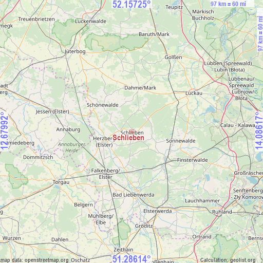
| Upper-left | 52.15725°, | 12.67992° |
| Center: | 51.72379°, | 13.38304° |
| Lower-right: | 51.28614°, | 14.08617° |
| Map W x H: | 96.9×96.9 km | = 60.2×60.2mi |
| max Lat: | 55.01917° ⇑30.9% North |
| Schlieben: | 51.72379° |
| min Lat: | ⇓69.1% South 47.40724° |
| min Long | Schlieben | max Long |
| 5.92978° | 13.38304° | 14.98853° |
| W 94.9%⇐ | ⇒5.1% E |
Elevation
Elevation of Schlieben is 92 m = 302 ft, and this is 157.1 m = 515 ft below average elevation for this country.
| Max E: |
1256 m = 4121 ft | 69.8% |
| Avg. | 249.1 m = 817 ft | |
| Schlieben | 92 m = 302 ft | |
Min E: |
-5 m = -16 ft | 30.2% |
See also: Germany elevation on elevation.city.
Geographical zone
Schlieben is located in North temperate zone (between Tropic of Cancer and the Arctic Circle). Distance of this North polar circle is 1650 km =1025.3 mi to North.| Distance of | km | miles | from Schlieben |
|---|---|---|---|
| North Pole | 4255.9 | 2644.5 | to North |
| Arctic Circle | 1650 | 1025.3 | to North |
| Tropic Cancer | 3145.2 | 1954.3 | to South |
| Equator | 5751.1 | 3573.6 | to South |


Nearby cities:
15 places around Schlieben: (largest is in red/bold)
• Dahme
16.5 km =10.3 mi,  10°
10°
• Doberlug-Kirchhain
16.5 km =10.3 mi,  131°
131°
• Falkenberg
18.1 km =11.2 mi,  212°
212°
• Herzberg
11.9 km =7.4 mi,  249°
249°
• Hohenbucko
7.5 km =4.7 mi,  50°
50°
• Holzdorf
18.6 km =11.6 mi,  289°
289°
• Ihlow
16.2 km =10.1 mi,  348°
348°
• Lebusa
8.4 km =5.2 mi,  17°
17°
• Rückersdorf
21.6 km =13.4 mi,  142°
142°
• Schilda
13.8 km =8.6 mi,  179°
179°
• Schönborn
15.6 km =9.7 mi,  151°
151°
• Schönewalde
15.9 km =9.9 mi,  108°
108°
• Sonnewalde
18.5 km =11.5 mi,  100°
100°
• Tröbitz
14.2 km =8.8 mi,  165°
165°
• Uebigau
15.5 km =9.6 mi,  201°
201°
Sources, notices
• [Note1] Compared only with cities in Germany existing in our database
• [Src1] Map data: © OpenStreetMap contributors (CC-BY-SA)
• [Src2] Other city data from geonames.org with taken over terms of usage.
• [Src3] Geographical zone / Annual Mean Temperature by Robert A. Rohde @ Wikipedia
