Uebigau geodata
Uebigau (Brandenburg) is a populated place; located in Germany in Europe/Berlin (GMT+2) time zone. With population of 2,300 people, there are 4670 cities with bigger population in this country. Compared to other cities in Germany, 67.5% of cities are located further ↓South; 94.4% of cities are located further ←West and 70.7% of cities have higher elevation than Uebigau. Note1
Administrative division(s):
- Level 1: Brandenburg
- Level 3: Landkreis Elbe-Elster
- Level 4: Uebigau-Wahrenbrück


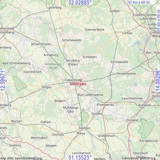
Uebigau GPS coordinates[2]
51° 35' 38.94" North, 13° 17' 59.388" East
| Map corner | latitude | longitude |
|---|---|---|
| Upper-left | 52.02885°, | 12.59671° |
| Center: | 51.59415°, | 13.29983° |
| Lower-right: | 51.15525°, | 14.00296° |
| Map W x H: | 97.1×97.1 km | = 60.3×60.3mi |
| max Lat: | 55.01917° ⇑32.5% North |
| Uebigau: | 51.59415° |
| min Lat: | ⇓67.5% South 47.40724° |
| min Long | Uebigau | max Long |
| 5.92978° | 13.29983° | 14.98853° |
| W 94.4%⇐ | ⇒5.6% E |
Elevation
Elevation of Uebigau is 87 m = 285 ft, and this is 162.1 m = 532 ft below average elevation for this country.
| Max E: |
1256 m = 4121 ft | 70.7% |
| Avg. | 249.1 m = 817 ft | |
| Uebigau | 87 m = 285 ft | |
Min E: |
-5 m = -16 ft | 29.3% |
See also: Germany elevation on elevation.city.
Geographical zone
Uebigau is located in North temperate zone (between Tropic of Cancer and the Arctic Circle). Distance of this North polar circle is 1664.4 km =1034.2 mi to North.| Distance of | km | miles | from Uebigau |
|---|---|---|---|
| North Pole | 4270.3 | 2653.4 | to North |
| Arctic Circle | 1664.4 | 1034.2 | to North |
| Tropic Cancer | 3130.8 | 1945.4 | to South |
| Equator | 5736.7 | 3564.6 | to South |


Nearby cities:
15 places around Uebigau: (largest is in red/bold)
• Arzberg
14.1 km =8.8 mi,  238°
238°
• Bad Liebenwerda
10.7 km =6.6 mi,  142°
142°
• Beilrode
16.4 km =10.2 mi,  259°
259°
• Belgern
17.4 km =10.8 mi,  224°
224°
• Doberlug-Kirchhain
18.5 km =11.5 mi,  79°
79°
• Falkenberg
4 km =2.5 mi, 256°
• Herzberg
11.7 km =7.3 mi,  331°
331°
• Hohenleipisch
20.2 km =12.6 mi,  121°
121°
• Mühlberg
18.6 km =11.6 mi,  196°
196°
• Nauwalde
21 km =13 mi,  158°
158°
• Rückersdorf
19 km =11.8 mi,  98°
98°
• Schilda
5.8 km =3.6 mi, 83°
• Schlieben
15.5 km =9.6 mi,  21°
21°
• Schönborn
13.1 km =8.1 mi,  87°
87°
• Tröbitz
9.2 km =5.7 mi, 85°
Sources, notices
• [Note1] Compared only with cities in Germany existing in our database
• [Src1] Map data: © OpenStreetMap contributors (CC-BY-SA)
• [Src2] Other city data from geonames.org with taken over terms of usage.
• [Src3] Geographical zone / Annual Mean Temperature by Robert A. Rohde @ Wikipedia
