Schilda geodata
Schilda (Brandenburg) is a seat of a fourth-order administrative division; located in Germany in Europe/Berlin (GMT+2) time zone. With population of 561 people, there are 9021 cities with bigger population in this country. Compared to other cities in Germany, 67.6% of cities are located further ↓South; 94.9% of cities are located further ←West and 67.1% of cities have higher elevation than Schilda. Note1


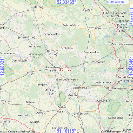
Schilda GPS coordinates[2]
51° 36' 0" North, 13° 22' 59.988" East
| Map corner | latitude | longitude |
|---|---|---|
| Upper-left | 52.03465°, | 12.68021° |
| Center: | 51.6°, | 13.38333° |
| Lower-right: | 51.16115°, | 14.08646° |
| Map W x H: | 97.1×97.1 km | = 60.3×60.3mi |
| max Lat: | 55.01917° ⇑32.4% North |
| Schilda: | 51.6° |
| min Lat: | ⇓67.6% South 47.40724° |
| min Long | Schilda | max Long |
| 5.92978° | 13.38333° | 14.98853° |
| W 94.9%⇐ | ⇒5.1% E |
Elevation
Elevation of Schilda is 107 m = 351 ft, and this is 142.1 m = 466 ft below average elevation for this country.
| Max E: |
1256 m = 4121 ft | 67.1% |
| Avg. | 249.1 m = 817 ft | |
| Schilda | 107 m = 351 ft | |
Min E: |
-5 m = -16 ft | 32.9% |
See also: Germany elevation on elevation.city.
Geographical zone
Schilda is located in North temperate zone (between Tropic of Cancer and the Arctic Circle). Distance of this North polar circle is 1663.8 km =1033.8 mi to North.| Distance of | km | miles | from Schilda |
|---|---|---|---|
| North Pole | 4269.7 | 2653.1 | to North |
| Arctic Circle | 1663.8 | 1033.8 | to North |
| Tropic Cancer | 3131.5 | 1945.8 | to South |
| Equator | 5737.4 | 3565.1 | to South |


Nearby cities:
15 places around Schilda: (largest is in red/bold)
• Arzberg
19.5 km =12.1 mi,  246°
246°
• Bad Liebenwerda
9.1 km =5.7 mi,  175°
175°
• Doberlug-Kirchhain
12.7 km =7.9 mi,  76°
76°
• Elsterwerda
18.2 km =11.3 mi,  148°
148°
• Falkenberg
9.8 km =6.1 mi,  260°
260°
• Herzberg
14.8 km =9.2 mi,  310°
310°
• Hohenbucko
19.4 km =12.1 mi,  17°
17°
• Hohenleipisch
16 km =9.9 mi,  133°
133°
• Nauwalde
20.3 km =12.6 mi,  174°
174°
• Rückersdorf
13.5 km =8.4 mi,  104°
104°
• Schlieben
13.8 km =8.6 mi,  359°
359°
• Schönborn
7.3 km =4.5 mi,  89°
89°
• Schönewalde
17.5 km =10.9 mi,  59°
59°
• Tröbitz
3.5 km =2.2 mi, 90°
• Uebigau
5.8 km =3.6 mi, 263°
Sources, notices
• [Note1] Compared only with cities in Germany existing in our database
• [Src1] Map data: © OpenStreetMap contributors (CC-BY-SA)
• [Src2] Other city data from geonames.org with taken over terms of usage.
• [Src3] Geographical zone / Annual Mean Temperature by Robert A. Rohde @ Wikipedia
