Aurich geodata
Aurich (Lower Saxony) is a seat of a third-order administrative division; located in Germany in Europe/Berlin (GMT+2) time zone. With population of 40,319 people, there are 317 cities with bigger population in this country. Compared to other cities in Germany, 85.2% of cities are located further ↓South; 87.4% of cities are located further →East and 94.3% of cities have higher elevation than Aurich. Note1


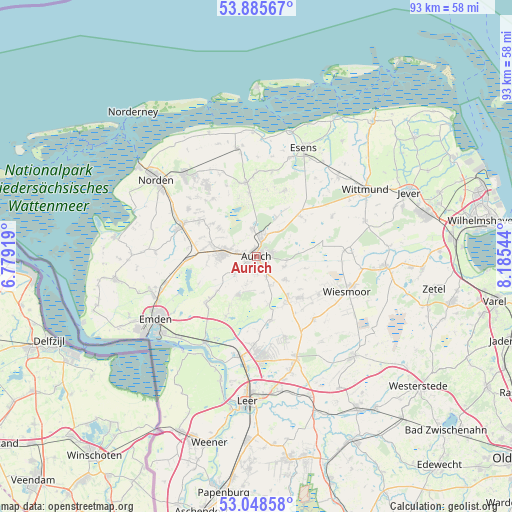
Aurich GPS coordinates[2]
53° 28' 9.084" North, 7° 28' 56.352" East
| Map corner | latitude | longitude |
|---|---|---|
| Upper-left | 53.88567°, | 6.77919° |
| Center: | 53.46919°, | 7.48232° |
| Lower-right: | 53.04858°, | 8.18544° |
| Map W x H: | 93.1×93.1 km | = 57.8×57.8mi |
| max Lat: | 55.01917° ⇑14.8% North |
| Aurich: | 53.46919° |
| min Lat: | ⇓85.2% South 47.40724° |
| min Long | Aurich | max Long |
| 5.92978° | 7.48232° | 14.98853° |
| W 12.6%⇐ | ⇒87.4% E |
Elevation
Elevation of Aurich is 10 m = 33 ft, and this is 239.1 m = 784 ft below average elevation for this country.
| Max E: |
1256 m = 4121 ft | 94.3% |
| Avg. | 249.1 m = 817 ft | |
| Aurich | 10 m = 33 ft | |
Min E: |
-5 m = -16 ft | 5.7% |
See also: Aurich elevation on elevation.city.
Geographical zone
Aurich is located in North temperate zone (between Tropic of Cancer and the Arctic Circle). Distance of this North polar circle is 1456 km =904.7 mi to North.| Distance of | km | miles | from Aurich |
|---|---|---|---|
| North Pole | 4061.8 | 2523.9 | to North |
| Arctic Circle | 1456 | 904.7 | to North |
| Tropic Cancer | 3339.3 | 2074.9 | to South |
| Equator | 5945.2 | 3694.2 | to South |


Nearby cities:
15 places around Aurich: (largest is in red/bold)
• Blomberg
13 km =8.1 mi,  22°
22°
• Eversmeer
10.6 km =6.6 mi,  342°
342°
• Halbemond
16.7 km =10.4 mi,  310°
310°
• Leezdorf
15 km =9.3 mi, 306°
• Marienhafe
15.1 km =9.4 mi,  293°
293°
• Mittegroßefehn
10.3 km =6.4 mi,  147°
147°
• Nenndorf
13.1 km =8.1 mi,  345°
345°
• Neukamperfehn
15.7 km =9.8 mi,  160°
160°
• Osteel
17.2 km =10.7 mi,  298°
298°
• Ostochtersum
15.5 km =9.6 mi,  10°
10°
• Rechtsupweg
12.2 km =7.6 mi, 305°
• Schweindorf
14.6 km =9.1 mi,  355°
355°
• Upgant-Schott
14.2 km =8.8 mi, 291°
• Utarp
16.4 km =10.2 mi,  0°
0°
• Westerholt
14.7 km =9.1 mi, 351°
Sources, notices
• [Note1] Compared only with cities in Germany existing in our database
• [Src1] Map data: © OpenStreetMap contributors (CC-BY-SA)
• [Src2] Other city data from geonames.org with taken over terms of usage.
• [Src3] Geographical zone / Annual Mean Temperature by Robert A. Rohde @ Wikipedia
