Deutschneudorf geodata
Deutschneudorf (Saxony) is a seat of a fourth-order administrative division; located in Germany in Europe/Berlin (GMT+2) time zone. In our database, there are 11009 cities with bigger population. Compared to other cities in Germany, 50.2% of cities are located further ↑North; 95.5% of cities are located further ←West and 98.1% of cities have lower elevation than Deutschneudorf. Note1


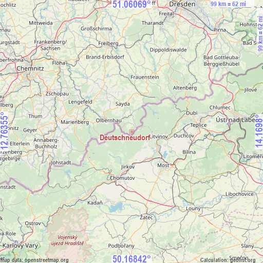
Deutschneudorf GPS coordinates[2]
50° 37' 0.012" North, 13° 28' 0.012" East
| Map corner | latitude | longitude |
|---|---|---|
| Upper-left | 51.06069°, | 12.76355° |
| Center: | 50.61667°, | 13.46667° |
| Lower-right: | 50.16842°, | 14.1698° |
| Map W x H: | 99.2×99.2 km | = 61.6×61.6mi |
| max Lat: | 55.01917° ⇑50.2% North |
| Deutschneudorf: | 50.61667° |
| min Lat: | ⇓49.8% South 47.40724° |
| min Long | Deutschneudorf | max Long |
| 5.92978° | 13.46667° | 14.98853° |
| W 95.5%⇐ | ⇒4.5% E |
Elevation
Elevation of Deutschneudorf is 715 m = 2346 ft, and this is 465.9 m = 1529 ft above average elevation for this country.
| Max E: |
1256 m = 4121 ft | 1.9% |
| Deutschneudorf | 715 m 2346 ft | |
| Avg. | 249.1 m = 817 ft | |
Min E: |
-5 m = -16 ft | 98.1% |
See also: Germany elevation on elevation.city.
Geographical zone
Deutschneudorf is located in North temperate zone (between Tropic of Cancer and the Arctic Circle). Distance of this North polar circle is 1773.1 km =1101.8 mi to North.| Distance of | km | miles | from Deutschneudorf |
|---|---|---|---|
| North Pole | 4379 | 2721 | to North |
| Arctic Circle | 1773.1 | 1101.8 | to North |
| Tropic Cancer | 3022.1 | 1877.8 | to South |
| Equator | 5628 | 3497.1 | to South |


Nearby cities:
15 places around Deutschneudorf: (largest is in red/bold)
• Dorfchemnitz
16.7 km =10.4 mi,  355°
355°
• Frauenstein
21.3 km =13.2 mi,  13°
13°
• Heidersdorf
8.8 km =5.5 mi,  327°
327°
• Lengefeld
22.4 km =13.9 mi,  300°
300°
• Marienberg
21.9 km =13.6 mi,  279°
279°
• Mulda
21.6 km =13.4 mi,  350°
350°
• Neuhausen
6.6 km =4.1 mi,  0°
0°
• Olbernhau
9.9 km =6.2 mi, 298°
• Pfaffroda
12.4 km =7.7 mi,  318°
318°
• Pobershau
17.8 km =11.1 mi, 278°
• Pockau
18.9 km =11.7 mi, 299°
• Rechenberg-Bienenmühle
14.3 km =8.9 mi,  19°
19°
• Sayda
11 km =6.8 mi,  343°
343°
• Seiffen
3.9 km =2.4 mi, 342°
• Zöblitz
17.4 km =10.8 mi,  285°
285°
Sources, notices
• [Note1] Compared only with cities in Germany existing in our database
• [Src1] Map data: © OpenStreetMap contributors (CC-BY-SA)
• [Src2] Other city data from geonames.org with taken over terms of usage.
• [Src3] Geographical zone / Annual Mean Temperature by Robert A. Rohde @ Wikipedia
