Rechenberg-Bienenmühle geodata
Rechenberg-Bienenmühle (Saxony) is a seat of a fourth-order administrative division; located in Germany in Europe/Berlin (GMT+2) time zone. With population of 2,506 people, there are 4436 cities with bigger population in this country. Compared to other cities in Germany, 53.1% of cities are located further ↓South; 96% of cities are located further ←West and 94.1% of cities have lower elevation than Rechenberg-Bienenmühle. Note1
Administrative division(s):
- Level 1: Saxony
- Level 3: Landkreis Mittelsachsen
- Level 4: Rechenberg-Bienenmühle
Current local time in Rechenberg-Bienenmühle:
04:04 PM, TuesdayDifference from your time zone: hours


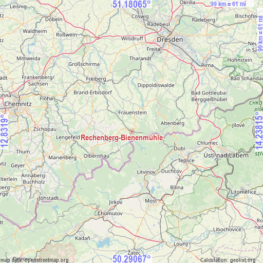
Rechenberg-Bienenmühle GPS coordinates[2]
50° 44' 15.972" North, 13° 32' 6.072" East
| Map corner | latitude | longitude |
|---|---|---|
| Upper-left | 51.18065°, | 12.8319° |
| Center: | 50.73777°, | 13.53502° |
| Lower-right: | 50.29067°, | 14.23815° |
| Map W x H: | 99×99 km | = 61.5×61.5mi |
| max Lat: | 55.01917° ⇑46.9% North |
| Rechenberg-Bienenmühle: | 50.73777° |
| min Lat: | ⇓53.1% South 47.40724° |
| min Long | Rechenberg-Bien | max Long |
| 5.92978° | 13.53502° | 14.98853° |
| W 96%⇐ | ⇒4% E |
Elevation
Elevation of Rechenberg-Bienenmühle is 577 m = 1893 ft, and this is 327.9 m = 1076 ft above average elevation for this country.
| Max E: |
1256 m = 4121 ft | 5.9% |
| Rechenberg-Bienenmühle | 577 m 1893 ft | |
| Avg. | 249.1 m = 817 ft | |
Min E: |
-5 m = -16 ft | 94.1% |
See also: Germany elevation on elevation.city.
Geographical zone
Rechenberg-Bienenmühle is located in North temperate zone (between Tropic of Cancer and the Arctic Circle). Distance of this North polar circle is 1759.7 km =1093.4 mi to North.| Distance of | km | miles | from Rechenberg-Bienenmühle |
|---|---|---|---|
| North Pole | 4365.6 | 2712.7 | to North |
| Arctic Circle | 1759.7 | 1093.4 | to North |
| Tropic Cancer | 3035.6 | 1886.2 | to South |
| Equator | 5641.5 | 3505.5 | to South |


Nearby cities:
15 places around Rechenberg-Bienenmühle: (largest is in red/bold)
• Altenberg
15.7 km =9.8 mi,  78°
78°
• Deutschneudorf
14.3 km =8.9 mi,  199°
199°
• Dorfchemnitz
6.8 km =4.2 mi,  298°
298°
• Frauenstein
7.2 km =4.5 mi,  1°
1°
• Großhartmannsdorf
15.8 km =9.8 mi, 296°
• Heidersdorf
11.3 km =7 mi,  237°
237°
• Lichtenberg
13.3 km =8.3 mi,  324°
324°
• Mulda
11.5 km =7.1 mi,  312°
312°
• Neuhausen
8.3 km =5.2 mi,  214°
214°
• Olbernhau
16.2 km =10.1 mi, 237°
• Pfaffroda
13.7 km =8.5 mi,  252°
252°
• Pretzschendorf
15.1 km =9.4 mi,  357°
357°
• Sayda
8.5 km =5.3 mi, 249°
• Schmiedeberg
14.8 km =9.2 mi,  42°
42°
• Seiffen
11.4 km =7.1 mi, 211°
Sources, notices
• [Note1] Compared only with cities in Germany existing in our database
• [Src1] Map data: © OpenStreetMap contributors (CC-BY-SA)
• [Src2] Other city data from geonames.org with taken over terms of usage.
• [Src3] Geographical zone / Annual Mean Temperature by Robert A. Rohde @ Wikipedia
