Dauchingen geodata
Dauchingen (Baden-Württemberg) is a seat of a fourth-order administrative division; located in Germany in Europe/Berlin (GMT+2) time zone. With population of 3,665 people, there are 3501 cities with bigger population in this country. Compared to other cities in Germany, 94.2% of cities are located further ↑North; 70.6% of cities are located further →East and 98.4% of cities have lower elevation than Dauchingen. Note1
Administrative division(s):
- Level 1: Baden-Württemberg
- Level 2: Freiburg Region
- Level 3: Schwarzwald-Baar-Kreis
- Level 4: Dauchingen


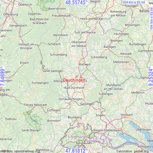
Dauchingen GPS coordinates[2]
48° 5' 23.748" North, 8° 33' 0.396" East
| Map corner | latitude | longitude |
|---|---|---|
| Upper-left | 48.55745°, | 7.84699° |
| Center: | 48.08993°, | 8.55011° |
| Lower-right: | 47.61812°, | 9.25324° |
| Map W x H: | 104.4×104.4 km | = 64.9×64.9mi |
| max Lat: | 55.01917° ⇑94.2% North |
| Dauchingen: | 48.08993° |
| min Lat: | ⇓5.8% South 47.40724° |
| min Long | Dauchingen | max Long |
| 5.92978° | 8.55011° | 14.98853° |
| W 29.4%⇐ | ⇒70.6% E |
Elevation
Elevation of Dauchingen is 731 m = 2398 ft, and this is 481.9 m = 1581 ft above average elevation for this country.
| Max E: |
1256 m = 4121 ft | 1.6% |
| Dauchingen | 731 m 2398 ft | |
| Avg. | 249.1 m = 817 ft | |
Min E: |
-5 m = -16 ft | 98.4% |
See also: Germany elevation on elevation.city.
Geographical zone
Dauchingen is located in North temperate zone (between Tropic of Cancer and the Arctic Circle). Distance of this North polar circle is 2054.1 km =1276.4 mi to North.| Distance of | km | miles | from Dauchingen |
|---|---|---|---|
| North Pole | 4660 | 2895.6 | to North |
| Arctic Circle | 2054.1 | 1276.4 | to North |
| Tropic Cancer | 2741.2 | 1703.3 | to South |
| Equator | 5347.1 | 3322.5 | to South |


Nearby cities:
15 places around Dauchingen: (largest is in red/bold)
• Aldingen
11.2 km =7 mi,  84°
84°
• Bad Dürrheim
7.8 km =4.8 mi,  190°
190°
• Deißlingen
4.9 km =3 mi,  59°
59°
• Durchhausen
10.8 km =6.7 mi,  121°
121°
• Frittlingen
12.4 km =7.7 mi,  70°
70°
• Gunningen
12 km =7.5 mi,  111°
111°
• Königsfeld im Schwarzwald
11.1 km =6.9 mi,  298°
298°
• Mönchweiler
9.6 km =6 mi,  276°
276°
• Niedereschach
5 km =3.1 mi,  345°
345°
• Rottweil
10.4 km =6.5 mi,  33°
33°
• Talheim
11.9 km =7.4 mi,  133°
133°
• Trossingen
7.1 km =4.4 mi,  101°
101°
• Tuningen
7.3 km =4.5 mi,  149°
149°
• Villingen-Schwenningen
5.2 km =3.2 mi,  233°
233°
• Zimmern ob Rottweil
9.1 km =5.7 mi,  21°
21°
Sources, notices
• [Note1] Compared only with cities in Germany existing in our database
• [Src1] Map data: © OpenStreetMap contributors (CC-BY-SA)
• [Src2] Other city data from geonames.org with taken over terms of usage.
• [Src3] Geographical zone / Annual Mean Temperature by Robert A. Rohde @ Wikipedia
