Villingen-Schwenningen geodata
Villingen-Schwenningen (Baden-Württemberg) is a seat of a third-order administrative division; located in Germany in Europe/Berlin (GMT+2) time zone. With population of 81,770 people, there are 119 cities with bigger population in this country. Compared to other cities in Germany, 94.7% of cities are located further ↑North; 71.1% of cities are located further →East and 98.8% of cities have lower elevation than Villingen-Schwenningen. Note1
Administrative division(s):
- Level 1: Baden-Württemberg
- Level 2: Freiburg Region
- Level 3: Schwarzwald-Baar-Kreis
- Level 4: Villingen-Schwenningen


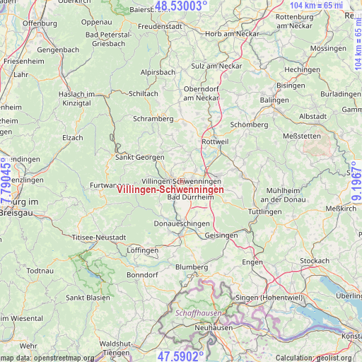
Villingen-Schwenningen GPS coordinates[2]
48° 3' 44.136" North, 8° 29' 36.888" East
| Map corner | latitude | longitude |
|---|---|---|
| Upper-left | 48.53003°, | 7.79045° |
| Center: | 48.06226°, | 8.49358° |
| Lower-right: | 47.5902°, | 9.1967° |
| Map W x H: | 104.5×104.5 km | = 64.9×64.9mi |
| max Lat: | 55.01917° ⇑94.7% North |
| Villingen-Schwenningen: | 48.06226° |
| min Lat: | ⇓5.3% South 47.40724° |
| min Long | Villingen-Schwe | max Long |
| 5.92978° | 8.49358° | 14.98853° |
| W 28.9%⇐ | ⇒71.1% E |
Elevation
Elevation of Villingen-Schwenningen is 757 m = 2484 ft, and this is 507.9 m = 1666 ft above average elevation for this country.
| Max E: |
1256 m = 4121 ft | 1.2% |
| Villingen-Schwenningen | 757 m 2484 ft | |
| Avg. | 249.1 m = 817 ft | |
Min E: |
-5 m = -16 ft | 98.8% |
See also: Villingen-Schwenningen elevation on elevation.city.
Geographical zone
Villingen-Schwenningen is located in North temperate zone (between Tropic of Cancer and the Arctic Circle). Distance of this North polar circle is 2057.2 km =1278.3 mi to North.| Distance of | km | miles | from Villingen-Schwenningen |
|---|---|---|---|
| North Pole | 4663 | 2897.5 | to North |
| Arctic Circle | 2057.2 | 1278.3 | to North |
| Tropic Cancer | 2738.1 | 1701.4 | to South |
| Equator | 5344 | 3320.6 | to South |


Nearby cities:
15 places around Villingen-Schwenningen: (largest is in red/bold)
• Bad Dürrheim
5.4 km =3.4 mi,  149°
149°
• Dauchingen
5.2 km =3.2 mi,  53°
53°
• Deißlingen
10.1 km =6.3 mi,  56°
56°
• Donaueschingen
11.9 km =7.4 mi,  178°
178°
• Durchhausen
13.7 km =8.5 mi,  100°
100°
• Königsfeld im Schwarzwald
10.1 km =6.3 mi,  326°
326°
• Mönchweiler
6.8 km =4.2 mi,  308°
308°
• Niedereschach
8.4 km =5.2 mi,  20°
20°
• Sankt Georgen im Schwarzwald
13.8 km =8.6 mi,  301°
301°
• Talheim
13.8 km =8.6 mi,  111°
111°
• Trossingen
11.3 km =7 mi,  81°
81°
• Tuningen
8.5 km =5.3 mi, 112°
• Unterkirnach
9.7 km =6 mi,  281°
281°
• Vöhrenbach
14.5 km =9 mi,  264°
264°
• Zimmern ob Rottweil
13.8 km =8.6 mi,  32°
32°
Sources, notices
• [Note1] Compared only with cities in Germany existing in our database
• [Src1] Map data: © OpenStreetMap contributors (CC-BY-SA)
• [Src2] Other city data from geonames.org with taken over terms of usage.
• [Src3] Geographical zone / Annual Mean Temperature by Robert A. Rohde @ Wikipedia
