Königsfeld im Schwarzwald geodata
Königsfeld im Schwarzwald (Baden-Württemberg) is a seat of a fourth-order administrative division; located in Germany in Europe/Berlin (GMT+2) time zone. With population of 6,212 people, there are 2396 cities with bigger population in this country. Compared to other cities in Germany, 93.5% of cities are located further ↑North; 71.8% of cities are located further →East and 98.8% of cities have lower elevation than Königsfeld im Schwarzwald. Note1
Administrative division(s):
- Level 1: Baden-Württemberg
- Level 2: Freiburg Region
- Level 3: Schwarzwald-Baar-Kreis
- Level 4: Königsfeld im Schwarzwald
Current local time in Königsfeld im Schwarzwald:
01:10 PM, TuesdayDifference from your time zone: hours


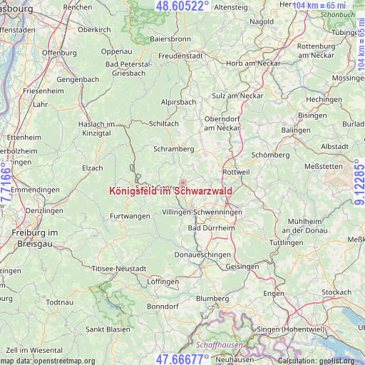
Königsfeld im Schwarzwald GPS coordinates[2]
48° 8' 17.304" North, 8° 25' 11.028" East
| Map corner | latitude | longitude |
|---|---|---|
| Upper-left | 48.60522°, | 7.7166° |
| Center: | 48.13814°, | 8.41973° |
| Lower-right: | 47.66677°, | 9.12285° |
| Map W x H: | 104.3×104.3 km | = 64.8×64.8mi |
| max Lat: | 55.01917° ⇑93.5% North |
| Königsfeld im Schwarzwald: | 48.13814° |
| min Lat: | ⇓6.5% South 47.40724° |
| min Long | Königsfeld im | max Long |
| 5.92978° | 8.41973° | 14.98853° |
| W 28.2%⇐ | ⇒71.8% E |
Elevation
Elevation of Königsfeld im Schwarzwald is 761 m = 2497 ft, and this is 511.9 m = 1679 ft above average elevation for this country.
| Max E: |
1256 m = 4121 ft | 1.2% |
| Königsfeld im Schwarzwald | 761 m 2497 ft | |
| Avg. | 249.1 m = 817 ft | |
Min E: |
-5 m = -16 ft | 98.8% |
See also: Germany elevation on elevation.city.
Geographical zone
Königsfeld im Schwarzwald is located in North temperate zone (between Tropic of Cancer and the Arctic Circle). Distance of this North polar circle is 2048.7 km =1273 mi to North.| Distance of | km | miles | from Königsfeld im Schwarzwald |
|---|---|---|---|
| North Pole | 4654.6 | 2892.2 | to North |
| Arctic Circle | 2048.7 | 1273 | to North |
| Tropic Cancer | 2746.5 | 1706.6 | to South |
| Equator | 5352.5 | 3325.9 | to South |


Nearby cities:
15 places around Königsfeld im Schwarzwald: (largest is in red/bold)
• Dauchingen
11.1 km =6.9 mi,  118°
118°
• Dunningen
10.5 km =6.5 mi,  37°
37°
• Hardt
5 km =3.1 mi,  357°
357°
• Lauterbach/Schwarzwald
11.7 km =7.3 mi,  330°
330°
• Mönchweiler
4.2 km =2.6 mi,  177°
177°
• Niedereschach
8.4 km =5.2 mi,  93°
93°
• Sankt Georgen im Schwarzwald
6.4 km =4 mi,  258°
258°
• Schramberg
9.9 km =6.2 mi,  345°
345°
• Seedorf
13.4 km =8.3 mi,  22°
22°
• Tennenbronn
7.7 km =4.8 mi,  319°
319°
• Unterkirnach
7.7 km =4.8 mi,  211°
211°
• Villingen-Schwenningen
10.1 km =6.3 mi,  146°
146°
• Villingendorf
13.9 km =8.6 mi,  60°
60°
• Vöhrenbach
13.2 km =8.2 mi,  222°
222°
• Zimmern ob Rottweil
13.3 km =8.3 mi,  76°
76°
In other languages:
- In German: Königsfeld im Schwarzwald, Königsfeld
- In Russian: Кёнигсфельд
- In Chinese: 黑林山区克尼格斯费尔德
Sources, notices
• [Note1] Compared only with cities in Germany existing in our database
• [Src1] Map data: © OpenStreetMap contributors (CC-BY-SA)
• [Src2] Other city data from geonames.org with taken over terms of usage.
• [Src3] Geographical zone / Annual Mean Temperature by Robert A. Rohde @ Wikipedia
