Eisenach geodata
Eisenach (Thuringia) is a populated place; located in Germany in Europe/Berlin (GMT+2) time zone. With population of 43,846 people, there are 275 cities with bigger population in this country. Compared to other cities in Germany, 57.8% of cities are located further ↓South; 55.6% of cities are located further ←West and 51.5% of cities have higher elevation than Eisenach. Note1


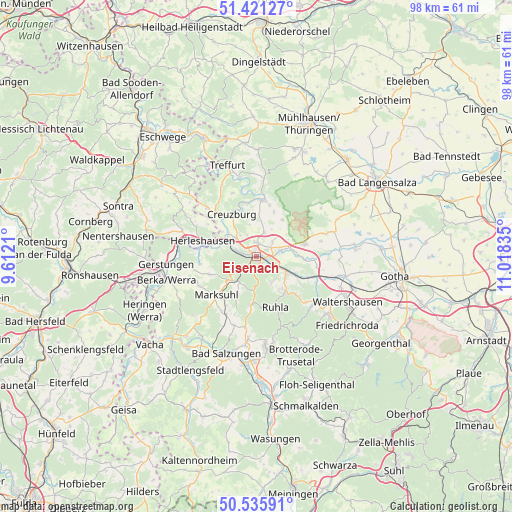
Eisenach GPS coordinates[2]
50° 58' 50.52" North, 10° 18' 54.792" East
| Map corner | latitude | longitude |
|---|---|---|
| Upper-left | 51.42127°, | 9.6121° |
| Center: | 50.9807°, | 10.31522° |
| Lower-right: | 50.53591°, | 11.01835° |
| Map W x H: | 98.4×98.4 km | = 61.1×61.1mi |
| max Lat: | 55.01917° ⇑42.2% North |
| Eisenach: | 50.9807° |
| min Lat: | ⇓57.8% South 47.40724° |
| min Long | Eisenach | max Long |
| 5.92978° | 10.31522° | 14.98853° |
| W 55.6%⇐ | ⇒44.4% E |
Elevation
Elevation of Eisenach is 215 m = 705 ft, and this is 34.1 m = 112 ft below average elevation for this country.
| Max E: |
1256 m = 4121 ft | 51.5% |
| Avg. | 249.1 m = 817 ft | |
| Eisenach | 215 m = 705 ft | |
Min E: |
-5 m = -16 ft | 48.5% |
See also: Eisenach elevation on elevation.city.
Geographical zone
Eisenach is located in North temperate zone (between Tropic of Cancer and the Arctic Circle). Distance of this North polar circle is 1732.7 km =1076.6 mi to North.| Distance of | km | miles | from Eisenach |
|---|---|---|---|
| North Pole | 4338.5 | 2695.8 | to North |
| Arctic Circle | 1732.7 | 1076.6 | to North |
| Tropic Cancer | 3062.6 | 1903 | to South |
| Equator | 5668.5 | 3522.2 | to South |


Nearby cities:
15 places around Eisenach: (largest is in red/bold)
• Bischofroda
9.1 km =5.7 mi,  22°
22°
• Creuzburg
9.3 km =5.8 mi,  329°
329°
• Ebenshausen
11.5 km =7.1 mi,  354°
354°
• Herleshausen
10.7 km =6.6 mi,  285°
285°
• Krauthausen
5.2 km =3.2 mi,  319°
319°
• Lauchröden
11.2 km =7 mi,  277°
277°
• Lauterbach
9.9 km =6.2 mi,  14°
14°
• Marksuhl
10.8 km =6.7 mi,  228°
228°
• Mihla
10.7 km =6.6 mi, 6°
• Oberellen
9.8 km =6.1 mi,  248°
248°
• Ruhla
10.4 km =6.5 mi,  160°
160°
• Seebach
10.1 km =6.3 mi,  135°
135°
• Thal
8.9 km =5.5 mi, 142°
• Unterellen
11 km =6.8 mi,  261°
261°
• Wolfsburg-Unkeroda
6.3 km =3.9 mi,  212°
212°
Sources, notices
• [Note1] Compared only with cities in Germany existing in our database
• [Src1] Map data: © OpenStreetMap contributors (CC-BY-SA)
• [Src2] Other city data from geonames.org with taken over terms of usage.
• [Src3] Geographical zone / Annual Mean Temperature by Robert A. Rohde @ Wikipedia
