Krauthausen geodata
Krauthausen (Thuringia) is a seat of a fourth-order administrative division; located in Germany in Europe/Berlin (GMT+2) time zone. With population of 1,667 people, there are 5574 cities with bigger population in this country. Compared to other cities in Germany, 58.3% of cities are located further ↓South; 54.6% of cities are located further ←West and 52.3% of cities have lower elevation than Krauthausen. Note1


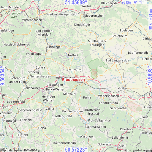
Krauthausen GPS coordinates[2]
51° 1' 0.012" North, 10° 16' 0.012" East
| Map corner | latitude | longitude |
|---|---|---|
| Upper-left | 51.45689°, | 9.56354° |
| Center: | 51.01667°, | 10.26667° |
| Lower-right: | 50.57223°, | 10.9698° |
| Map W x H: | 98.4×98.4 km | = 61.1×61.1mi |
| max Lat: | 55.01917° ⇑41.7% North |
| Krauthausen: | 51.01667° |
| min Lat: | ⇓58.3% South 47.40724° |
| min Long | Krauthausen | max Long |
| 5.92978° | 10.26667° | 14.98853° |
| W 54.6%⇐ | ⇒45.4% E |
Elevation
Elevation of Krauthausen is 242 m = 794 ft, and this is 7.1 m = 23 ft below average elevation for this country.
| Max E: |
1256 m = 4121 ft | 47.7% |
| Avg. | 249.1 m = 817 ft | |
| Krauthausen | 242 m = 794 ft | |
Min E: |
-5 m = -16 ft | 52.3% |
See also: Germany elevation on elevation.city.
Geographical zone
Krauthausen is located in North temperate zone (between Tropic of Cancer and the Arctic Circle). Distance of this North polar circle is 1728.7 km =1074.2 mi to North.| Distance of | km | miles | from Krauthausen |
|---|---|---|---|
| North Pole | 4334.5 | 2693.3 | to North |
| Arctic Circle | 1728.7 | 1074.2 | to North |
| Tropic Cancer | 3066.6 | 1905.5 | to South |
| Equator | 5672.5 | 3524.7 | to South |


Nearby cities:
15 places around Krauthausen: (largest is in red/bold)
• Bischofroda
8.1 km =5 mi,  57°
57°
• Creuzburg
4.2 km =2.6 mi,  341°
341°
• Ebenshausen
7.8 km =4.8 mi,  17°
17°
• Eisenach
5.2 km =3.2 mi,  139°
139°
• Frankenroda
9.3 km =5.8 mi,  7°
7°
• Herleshausen
7 km =4.3 mi,  260°
260°
• Ifta
8.1 km =5 mi,  313°
313°
• Lauchröden
8.1 km =5 mi,  251°
251°
• Lauterbach
8.1 km =5 mi,  46°
46°
• Marksuhl
12.1 km =7.5 mi,  202°
202°
• Mihla
8 km =5 mi,  34°
34°
• Nazza
11.9 km =7.4 mi, 23°
• Oberellen
9.5 km =5.9 mi,  216°
216°
• Unterellen
9.3 km =5.8 mi,  233°
233°
• Wolfsburg-Unkeroda
9.3 km =5.8 mi,  180°
180°
Sources, notices
• [Note1] Compared only with cities in Germany existing in our database
• [Src1] Map data: © OpenStreetMap contributors (CC-BY-SA)
• [Src2] Other city data from geonames.org with taken over terms of usage.
• [Src3] Geographical zone / Annual Mean Temperature by Robert A. Rohde @ Wikipedia
