Walpertskirchen geodata
Walpertskirchen (Bavaria) is a seat of a fourth-order administrative division; located in Germany in Europe/Berlin (GMT+2) time zone. With population of 1,960 people, there are 5115 cities with bigger population in this country. Compared to other cities in Germany, 91.8% of cities are located further ↑North; 81.5% of cities are located further ←West and 88.1% of cities have lower elevation than Walpertskirchen. Note1
Administrative division(s):
- Level 1: Bavaria
- Level 2: Upper Bavaria
- Level 3: Landkreis Erding
- Level 4: Walpertskirchen


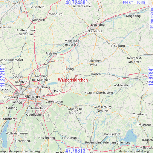
Walpertskirchen GPS coordinates[2]
48° 15' 30.24" North, 11° 58' 30.972" East
| Map corner | latitude | longitude |
|---|---|---|
| Upper-left | 48.72438°, | 11.27215° |
| Center: | 48.2584°, | 11.97527° |
| Lower-right: | 47.78813°, | 12.6784° |
| Map W x H: | 104.1×104.1 km | = 64.7×64.7mi |
| max Lat: | 55.01917° ⇑91.8% North |
| Walpertskirchen: | 48.2584° |
| min Lat: | ⇓8.2% South 47.40724° |
| min Long | Walpertskirchen | max Long |
| 5.92978° | 11.97527° | 14.98853° |
| W 81.5%⇐ | ⇒18.5% E |
Elevation
Elevation of Walpertskirchen is 495 m = 1624 ft, and this is 245.9 m = 807 ft above average elevation for this country.
| Max E: |
1256 m = 4121 ft | 11.9% |
| Walpertskirchen | 495 m 1624 ft | |
| Avg. | 249.1 m = 817 ft | |
Min E: |
-5 m = -16 ft | 88.1% |
See also: Germany elevation on elevation.city.
Geographical zone
Walpertskirchen is located in North temperate zone (between Tropic of Cancer and the Arctic Circle). Distance of this North polar circle is 2035.3 km =1264.7 mi to North.| Distance of | km | miles | from Walpertskirchen |
|---|---|---|---|
| North Pole | 4641.2 | 2883.9 | to North |
| Arctic Circle | 2035.3 | 1264.7 | to North |
| Tropic Cancer | 2759.9 | 1714.9 | to South |
| Equator | 5365.8 | 3334.2 | to South |


Nearby cities:
15 places around Walpertskirchen: (largest is in red/bold)
• Bockhorn
6.3 km =3.9 mi,  7°
7°
• Buch am Buchrain
5 km =3.1 mi,  163°
163°
• Erding
7.3 km =4.5 mi,  316°
316°
• Forstern
8.3 km =5.2 mi,  179°
179°
• Forstinning
11 km =6.8 mi,  205°
205°
• Hohenlinden
11.5 km =7.1 mi,  172°
172°
• Isen
7.9 km =4.9 mi,  130°
130°
• Lengdorf
5.5 km =3.4 mi,  91°
91°
• Markt Schwaben
11 km =6.8 mi,  225°
225°
• Moosinning
9.9 km =6.2 mi,  282°
282°
• Oberding
11.3 km =7 mi,  304°
304°
• Ottenhofen
8.2 km =5.1 mi,  235°
235°
• Pastetten
7 km =4.3 mi,  199°
199°
• Stammham
8.9 km =5.5 mi, 298°
• Wörth
5.6 km =3.5 mi,  254°
254°
Sources, notices
• [Note1] Compared only with cities in Germany existing in our database
• [Src1] Map data: © OpenStreetMap contributors (CC-BY-SA)
• [Src2] Other city data from geonames.org with taken over terms of usage.
• [Src3] Geographical zone / Annual Mean Temperature by Robert A. Rohde @ Wikipedia
