Bismark geodata
Bismark (Saxony-Anhalt) is a populated place; located in Germany in Europe/Berlin (GMT+2) time zone. With population of 3,313 people, there are 3745 cities with bigger population in this country. Compared to other cities in Germany, 79.3% of cities are located further ↓South; 75.1% of cities are located further ←West and 78.9% of cities have higher elevation than Bismark. Note1
Administrative division(s):
- Level 1: Saxony-Anhalt
- Level 3: Landkreis Stendal
- Level 4: Bismark (Altmark)


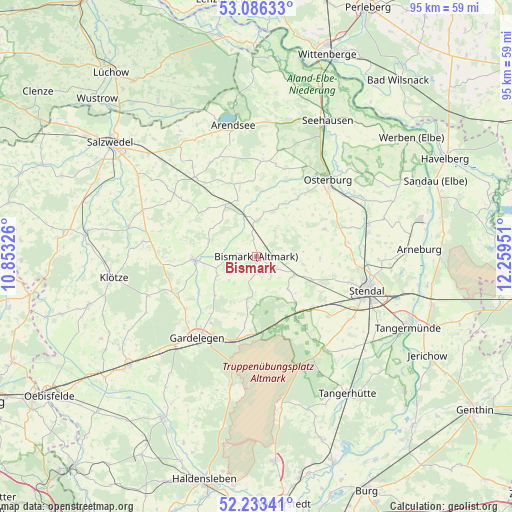
Bismark GPS coordinates[2]
52° 39' 43.02" North, 11° 33' 22.968" East
| Map corner | latitude | longitude |
|---|---|---|
| Upper-left | 53.08633°, | 10.85326° |
| Center: | 52.66195°, | 11.55638° |
| Lower-right: | 52.23341°, | 12.25951° |
| Map W x H: | 94.8×94.8 km | = 58.9×58.9mi |
| max Lat: | 55.01917° ⇑20.7% North |
| Bismark: | 52.66195° |
| min Lat: | ⇓79.3% South 47.40724° |
| min Long | Bismark | max Long |
| 5.92978° | 11.55638° | 14.98853° |
| W 75.1%⇐ | ⇒24.9% E |
Elevation
Elevation of Bismark is 50 m = 164 ft, and this is 199.1 m = 653 ft below average elevation for this country.
| Max E: |
1256 m = 4121 ft | 78.9% |
| Avg. | 249.1 m = 817 ft | |
| Bismark | 50 m = 164 ft | |
Min E: |
-5 m = -16 ft | 21.1% |
See also: Germany elevation on elevation.city.
Geographical zone
Bismark is located in North temperate zone (between Tropic of Cancer and the Arctic Circle). Distance of this North polar circle is 1545.7 km =960.5 mi to North.| Distance of | km | miles | from Bismark |
|---|---|---|---|
| North Pole | 4151.6 | 2579.7 | to North |
| Arctic Circle | 1545.7 | 960.5 | to North |
| Tropic Cancer | 3249.5 | 2019.1 | to South |
| Equator | 5855.5 | 3638.4 | to South |


Nearby cities:
15 places around Bismark: (largest is in red/bold)
• Badingen
8.2 km =5.1 mi,  135°
135°
• Brunau
11.3 km =7 mi,  328°
328°
• Bühne
14.5 km =9 mi,  282°
282°
• Engersen
15.2 km =9.4 mi,  252°
252°
• Flessau
13.4 km =8.3 mi,  35°
35°
• Jävenitz
15.8 km =9.8 mi,  194°
194°
• Kalbe
11.6 km =7.2 mi,  267°
267°
• Kleinau
15.6 km =9.7 mi,  348°
348°
• Kloster Neuendorf
16.4 km =10.2 mi,  202°
202°
• Kläden
7.8 km =4.8 mi,  115°
115°
• Lindstedt
8 km =5 mi, 192°
• Meßdorf
6.5 km =4 mi,  0°
0°
• Möringen
15 km =9.3 mi, 121°
• Rochau
13.6 km =8.5 mi,  68°
68°
• Uchtspringe
13.9 km =8.6 mi,  167°
167°
Sources, notices
• [Note1] Compared only with cities in Germany existing in our database
• [Src1] Map data: © OpenStreetMap contributors (CC-BY-SA)
• [Src2] Other city data from geonames.org with taken over terms of usage.
• [Src3] Geographical zone / Annual Mean Temperature by Robert A. Rohde @ Wikipedia
