Kläden geodata
Kläden (Saxony-Anhalt) is a populated place; located in Germany in Europe/Berlin (GMT+2) time zone. With population of 765 people, there are 8030 cities with bigger population in this country. Compared to other cities in Germany, 79.1% of cities are located further ↓South; 76.6% of cities are located further ←West and 82% of cities have higher elevation than Kläden. Note1
Administrative division(s):
- Level 1: Saxony-Anhalt
- Level 3: Landkreis Stendal
- Level 4: Bismark (Altmark)


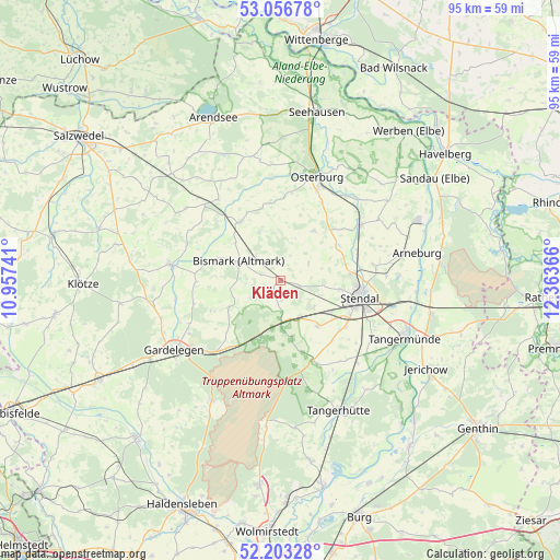
Kläden GPS coordinates[2]
52° 37' 55.596" North, 11° 39' 37.908" East
| Map corner | latitude | longitude |
|---|---|---|
| Upper-left | 53.05678°, | 10.95741° |
| Center: | 52.63211°, | 11.66053° |
| Lower-right: | 52.20328°, | 12.36366° |
| Map W x H: | 94.9×94.9 km | = 59×59mi |
| max Lat: | 55.01917° ⇑20.9% North |
| Kläden: | 52.63211° |
| min Lat: | ⇓79.1% South 47.40724° |
| min Long | Kläden | max Long |
| 5.92978° | 11.66053° | 14.98853° |
| W 76.6%⇐ | ⇒23.4% E |
Elevation
Elevation of Kläden is 42 m = 138 ft, and this is 207.1 m = 679 ft below average elevation for this country.
| Max E: |
1256 m = 4121 ft | 82% |
| Avg. | 249.1 m = 817 ft | |
| Kläden | 42 m = 138 ft | |
Min E: |
-5 m = -16 ft | 18% |
See also: Germany elevation on elevation.city.
Geographical zone
Kläden is located in North temperate zone (between Tropic of Cancer and the Arctic Circle). Distance of this North polar circle is 1549 km =962.5 mi to North.| Distance of | km | miles | from Kläden |
|---|---|---|---|
| North Pole | 4154.9 | 2581.7 | to North |
| Arctic Circle | 1549 | 962.5 | to North |
| Tropic Cancer | 3246.2 | 2017.1 | to South |
| Equator | 5852.1 | 3636.3 | to South |


Nearby cities:
15 places around Kläden: (largest is in red/bold)
• Badingen
2.8 km =1.7 mi,  205°
205°
• Bismark
7.8 km =4.8 mi,  295°
295°
• Dahlen
13.7 km =8.5 mi,  125°
125°
• Erxleben
15 km =9.3 mi,  28°
28°
• Flessau
14.2 km =8.8 mi,  2°
2°
• Insel
10 km =6.2 mi,  141°
141°
• Jarchau
16.1 km =10 mi,  80°
80°
• Lindstedt
9.9 km =6.2 mi,  242°
242°
• Lüderitz
14.8 km =9.2 mi,  157°
157°
• Meßdorf
12.1 km =7.5 mi,  324°
324°
• Möringen
7.3 km =4.5 mi, 128°
• Rochau
10.1 km =6.3 mi, 34°
• Stendal
13.7 km =8.5 mi,  101°
101°
• Uchtspringe
11 km =6.8 mi,  201°
201°
• Uenglingen
10.1 km =6.3 mi, 98°
Sources, notices
• [Note1] Compared only with cities in Germany existing in our database
• [Src1] Map data: © OpenStreetMap contributors (CC-BY-SA)
• [Src2] Other city data from geonames.org with taken over terms of usage.
• [Src3] Geographical zone / Annual Mean Temperature by Robert A. Rohde @ Wikipedia
