Möringen geodata
Möringen (Saxony-Anhalt) is a populated place; located in Germany in Europe/Berlin (GMT+2) time zone. With population of 795 people, there are 7920 cities with bigger population in this country. Compared to other cities in Germany, 78.6% of cities are located further ↓South; 77.9% of cities are located further ←West and 81.4% of cities have higher elevation than Möringen. Note1


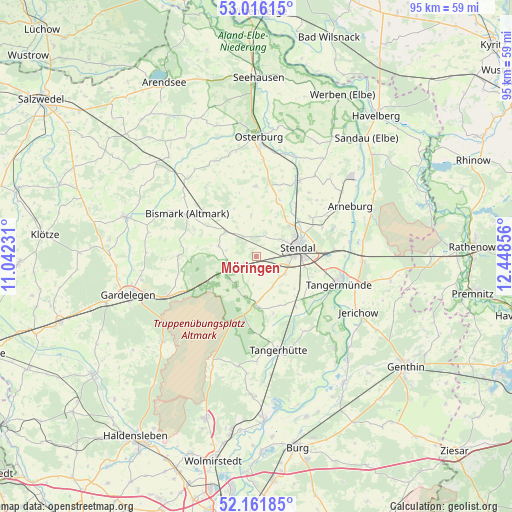
Möringen GPS coordinates[2]
52° 35' 27.888" North, 11° 44' 43.548" East
| Map corner | latitude | longitude |
|---|---|---|
| Upper-left | 53.01615°, | 11.04231° |
| Center: | 52.59108°, | 11.74543° |
| Lower-right: | 52.16185°, | 12.44856° |
| Map W x H: | 95×95 km | = 59×59mi |
| max Lat: | 55.01917° ⇑21.4% North |
| Möringen: | 52.59108° |
| min Lat: | ⇓78.6% South 47.40724° |
| min Long | Möringen | max Long |
| 5.92978° | 11.74543° | 14.98853° |
| W 77.9%⇐ | ⇒22.1% E |
Elevation
Elevation of Möringen is 43 m = 141 ft, and this is 206.1 m = 676 ft below average elevation for this country.
| Max E: |
1256 m = 4121 ft | 81.4% |
| Avg. | 249.1 m = 817 ft | |
| Möringen | 43 m = 141 ft | |
Min E: |
-5 m = -16 ft | 18.6% |
See also: Germany elevation on elevation.city.
Geographical zone
Möringen is located in North temperate zone (between Tropic of Cancer and the Arctic Circle). Distance of this North polar circle is 1553.6 km =965.4 mi to North.| Distance of | km | miles | from Möringen |
|---|---|---|---|
| North Pole | 4159.5 | 2584.6 | to North |
| Arctic Circle | 1553.6 | 965.4 | to North |
| Tropic Cancer | 3241.7 | 2014.3 | to South |
| Equator | 5847.6 | 3633.5 | to South |


Nearby cities:
15 places around Möringen: (largest is in red/bold)
• Badingen
7.3 km =4.5 mi,  285°
285°
• Bismark
15 km =9.3 mi,  301°
301°
• Dahlen
6.4 km =4 mi,  122°
122°
• Goldbeck
16 km =9.9 mi,  29°
29°
• Hassel
13.3 km =8.3 mi,  66°
66°
• Heeren
10.9 km =6.8 mi, 119°
• Insel
3.3 km =2.1 mi,  170°
170°
• Jarchau
12.4 km =7.7 mi,  54°
54°
• Kläden
7.3 km =4.5 mi,  308°
308°
• Lindstedt
14.5 km =9 mi,  270°
270°
• Lüderitz
9.1 km =5.7 mi,  181°
181°
• Rochau
12.9 km =8 mi,  359°
359°
• Stendal
7.8 km =4.8 mi,  77°
77°
• Uchtspringe
11.4 km =7.1 mi,  240°
240°
• Uenglingen
5.2 km =3.2 mi,  55°
55°
Sources, notices
• [Note1] Compared only with cities in Germany existing in our database
• [Src1] Map data: © OpenStreetMap contributors (CC-BY-SA)
• [Src2] Other city data from geonames.org with taken over terms of usage.
• [Src3] Geographical zone / Annual Mean Temperature by Robert A. Rohde @ Wikipedia
