Lindstedt geodata
Lindstedt (Saxony-Anhalt) is a populated place; located in Germany in Europe/Berlin (GMT+2) time zone. With population of 632 people, there are 8638 cities with bigger population in this country. Compared to other cities in Germany, 78.6% of cities are located further ↓South; 74.7% of cities are located further ←West and 81% of cities have higher elevation than Lindstedt. Note1
Administrative division(s):
- Level 1: Saxony-Anhalt
- Level 3: Altmarkkreis Salzwedel
- Level 4: Gardelegen


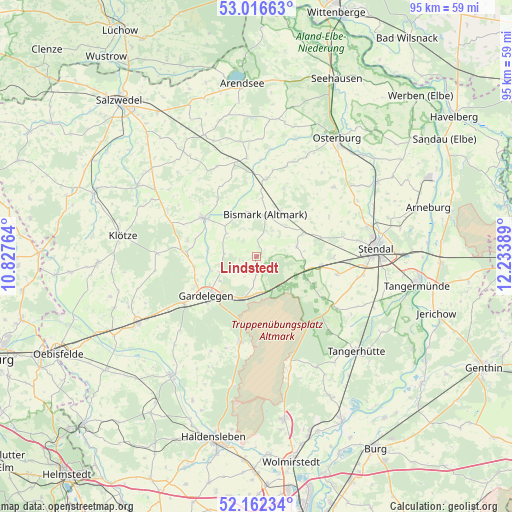
Lindstedt GPS coordinates[2]
52° 35' 29.652" North, 11° 31' 50.736" East
| Map corner | latitude | longitude |
|---|---|---|
| Upper-left | 53.01663°, | 10.82764° |
| Center: | 52.59157°, | 11.53076° |
| Lower-right: | 52.16234°, | 12.23389° |
| Map W x H: | 95×95 km | = 59×59mi |
| max Lat: | 55.01917° ⇑21.4% North |
| Lindstedt: | 52.59157° |
| min Lat: | ⇓78.6% South 47.40724° |
| min Long | Lindstedt | max Long |
| 5.92978° | 11.53076° | 14.98853° |
| W 74.7%⇐ | ⇒25.3% E |
Elevation
Elevation of Lindstedt is 44 m = 144 ft, and this is 205.1 m = 673 ft below average elevation for this country.
| Max E: |
1256 m = 4121 ft | 81% |
| Avg. | 249.1 m = 817 ft | |
| Lindstedt | 44 m = 144 ft | |
Min E: |
-5 m = -16 ft | 19% |
See also: Germany elevation on elevation.city.
Geographical zone
Lindstedt is located in North temperate zone (between Tropic of Cancer and the Arctic Circle). Distance of this North polar circle is 1553.5 km =965.3 mi to North.| Distance of | km | miles | from Lindstedt |
|---|---|---|---|
| North Pole | 4159.4 | 2584.5 | to North |
| Arctic Circle | 1553.5 | 965.3 | to North |
| Tropic Cancer | 3241.7 | 2014.3 | to South |
| Equator | 5847.6 | 3633.5 | to South |


Nearby cities:
15 places around Lindstedt: (largest is in red/bold)
• Badingen
7.8 km =4.8 mi,  75°
75°
• Berge
11.7 km =7.3 mi,  248°
248°
• Bismark
8 km =5 mi,  12°
12°
• Bühne
16.6 km =10.3 mi,  311°
311°
• Engersen
13.2 km =8.2 mi,  283°
283°
• Gardelegen
11.8 km =7.3 mi,  231°
231°
• Insel
15.4 km =9.6 mi,  102°
102°
• Jävenitz
7.8 km =4.8 mi,  195°
195°
• Kalbe
12.2 km =7.6 mi, 306°
• Kloster Neuendorf
8.6 km =5.3 mi,  211°
211°
• Kläden
9.9 km =6.2 mi,  62°
62°
• Letzlingen
16.5 km =10.3 mi,  190°
190°
• Meßdorf
14.5 km =9 mi, 6°
• Möringen
14.5 km =9 mi,  90°
90°
• Uchtspringe
7.4 km =4.6 mi,  140°
140°
Sources, notices
• [Note1] Compared only with cities in Germany existing in our database
• [Src1] Map data: © OpenStreetMap contributors (CC-BY-SA)
• [Src2] Other city data from geonames.org with taken over terms of usage.
• [Src3] Geographical zone / Annual Mean Temperature by Robert A. Rohde @ Wikipedia
